Fine Art Print > Europe > United Kingdom > Northern Ireland > County Down > Newcastle
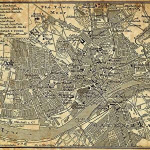
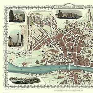
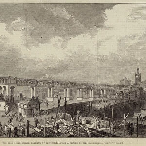
Fine Art Print : Newcastle upon Tyne city map 1895


![]()
Fine Art Prints from Fine Art Storehouse
Newcastle upon Tyne city map 1895
Meyers Konversations-Lexikon. Ein Nachschlagewerk des allgemeinen Wissens, 5th edition 17 volumes Bibliographisches Institut - Leipzig 1895-1897
Unleash your creativity and transform your space into a visual masterpiece!
THEPALMER
Media ID 18106765
© 2014 Roberto Adrian Photography
21"x14" (+3" Border) Fine Art Print
Step back in time with our exquisite Newcastle upon Tyne city map print from ThePalmer, available in the Media Storehouse Fine Art Prints collection. This captivating piece is taken from the 5th edition of Meyers Konversations-Lexikon published in 1895-1897. The intricate details of the map showcase the historical layout of Newcastle during that era, making it a stunning addition to any home or office space. Transport yourself back in time and add a touch of history to your decor with this beautiful fine art print.
21x14 image printed on 27x20 Fine Art Rag Paper with 3" (76mm) white border. Our Fine Art Prints are printed on 300gsm 100% acid free, PH neutral paper with archival properties. This printing method is used by museums and art collections to exhibit photographs and art reproductions.
Our fine art prints are high-quality prints made using a paper called Photo Rag. This 100% cotton rag fibre paper is known for its exceptional image sharpness, rich colors, and high level of detail, making it a popular choice for professional photographers and artists. Photo rag paper is our clear recommendation for a fine art paper print. If you can afford to spend more on a higher quality paper, then Photo Rag is our clear recommendation for a fine art paper print.
Estimated Image Size (if not cropped) is 53.3cm x 32.4cm (21" x 12.8")
Estimated Product Size is 68.6cm x 50.8cm (27" x 20")
These are individually made so all sizes are approximate
Artwork printed orientated as per the preview above, with landscape (horizontal) orientation to match the source image.
FEATURES IN THESE COLLECTIONS
> Europe
> United Kingdom
> Northern Ireland
> County Down
> Newcastle
> Maps and Charts
> Related Images
> Fine Art Storehouse
> Map
> Historical Maps
EDITORS COMMENTS
This print showcases a historical gem, the Newcastle upon Tyne city map from 1895. A true testament to the rich heritage of this vibrant English city, this meticulously detailed map offers a glimpse into its past. Published in Meyers Konversations-Lexikon's fifth edition, compiled by Bibliographisches Institut in Leipzig between 1895 and 1897, it serves as an invaluable resource for those interested in exploring the history and development of Newcastle upon Tyne. The intricate lines and delicate typography beautifully capture the essence of this bustling metropolis over a century ago. From its iconic landmarks like St. Nicholas Cathedral to its winding streets and charming neighborhoods, every corner is meticulously depicted on this vintage treasure. Expertly curated by THEPALMER at Fine Art Storehouse, this print allows us to immerse ourselves in the nostalgia of yesteryears while appreciating the craftsmanship behind cartography. Whether you're a history enthusiast or simply drawn to artistic representations of urban landscapes, this piece will undoubtedly spark curiosity and conversation. Hang it proudly on your wall or gift it to someone who cherishes Newcastle upon Tyne's fascinating past; either way, let yourself be transported back in time through the lens of this remarkable city map from 1895.
MADE IN THE USA
Safe Shipping with 30 Day Money Back Guarantee
FREE PERSONALISATION*
We are proud to offer a range of customisation features including Personalised Captions, Color Filters and Picture Zoom Tools
SECURE PAYMENTS
We happily accept a wide range of payment options so you can pay for the things you need in the way that is most convenient for you
* Options may vary by product and licensing agreement. Zoomed Pictures can be adjusted in the Cart.