Fine Art Print > Maps and Charts > Related Images
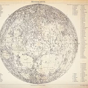
Fine Art Print : Mars map 1895

![]()
Fine Art Prints From Fine Art Storehouse
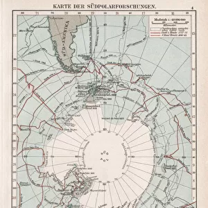
Mars map 1895
Meyers Konversations-Lexikon. Ein Nachschlagewerk des allgemeinen Wissens, 5th edition 17 volumes Bibliographisches Institut - Leipzig 1895-1897
Unleash your creativity and transform your space into a visual masterpiece!
THEPALMER
Media ID 18106747
© 2014 Roberto Adrian Photography
21"x14" (+3" Border) Fine Art Print
Step into the past with our exquisite Mars Map 1895 print from ThePalmer, available in our Fine Art Prints collection at Media Storehouse. This captivating piece is taken from the renowned Meyers Konversations-Lexikon, 5th edition published by Bibliographisches Institut in Leipzig between 1895 and 1897. The intricate detail and historical significance of this map, which depicts the known Mars landscape at the turn of the century, make it a must-have for any space enthusiast or history buff's collection. Bring a piece of the past into your home or office and transport yourself to a time when our understanding of the universe was just beginning to expand. Order your Mars Map 1895 fine art print today and let the adventure begin!
21x14 image printed on 27x20 Fine Art Rag Paper with 3" (76mm) white border. Our Fine Art Prints are printed on 300gsm 100% acid free, PH neutral paper with archival properties. This printing method is used by museums and art collections to exhibit photographs and art reproductions.
Our fine art prints are high-quality prints made using a paper called Photo Rag. This 100% cotton rag fibre paper is known for its exceptional image sharpness, rich colors, and high level of detail, making it a popular choice for professional photographers and artists. Photo rag paper is our clear recommendation for a fine art paper print. If you can afford to spend more on a higher quality paper, then Photo Rag is our clear recommendation for a fine art paper print.
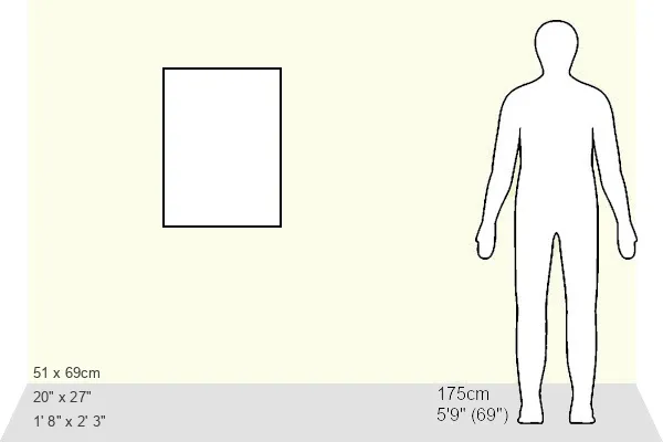
Estimated Image Size (if not cropped) is 34.1cm x 53.3cm (13.4" x 21")
Estimated Product Size is 50.8cm x 68.6cm (20" x 27")
These are individually made so all sizes are approximate
Artwork printed orientated as per the preview above, with portrait (vertical) orientation to match the source image.
FEATURES IN THESE COLLECTIONS
> Maps and Charts
> Related Images
> Fine Art Storehouse
> Map
> Historical Maps
EDITORS COMMENTS
This print showcases a remarkable piece of history - the Mars map from 1895. Taken from the renowned Meyers Konversations-Lexikon, an encyclopedia that served as a comprehensive source of knowledge during its time, this particular edition was published between 1895 and 1897 by Bibliographisches Institut in Leipzig. The intricately detailed map offers us a glimpse into how our understanding of the Red Planet has evolved over the years. Created long before modern technology allowed us to explore Mars up close, it represents humanity's early attempts to unravel the mysteries of our neighboring planet. Every line and contour on this vintage map tells a story - each marking representing countless hours spent studying and documenting Mars' surface features. From sprawling canyons to vast plains, these visual representations ignite our curiosity about what lies beyond Earth's boundaries. As we gaze upon this print by THEPALMER, we are transported back in time to an era when space exploration was still in its infancy. It serves as a reminder of how far we have come since then and inspires us to continue pushing the boundaries of scientific discovery. Whether you're an astronomy enthusiast or simply appreciate historical artifacts, this mesmerizing print is sure to captivate your imagination and spark conversations about mankind's eternal fascination with outer space.
MADE IN THE USA
Safe Shipping with 30 Day Money Back Guarantee
FREE PERSONALISATION*
We are proud to offer a range of customisation features including Personalised Captions, Color Filters and Picture Zoom Tools
SECURE PAYMENTS
We happily accept a wide range of payment options so you can pay for the things you need in the way that is most convenient for you
* Options may vary by product and licensing agreement. Zoomed Pictures can be adjusted in the Basket.