Fine Art Print > Africa > South Africa > Maps
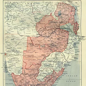
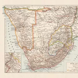
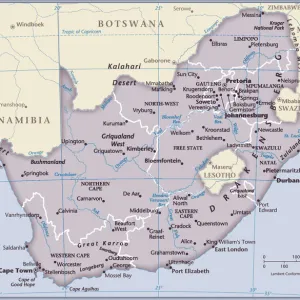
Fine Art Print : Map of South Africa 1900


![]()
Fine Art Prints from Fine Art Storehouse
Map of South Africa 1900
Meyers hand-Atlas Leipzig und Wien Verlag des Bibliographischen Instituts 1900
Unleash your creativity and transform your space into a visual masterpiece!
THEPALMER
Media ID 18106903
© 2014 Roberto Adrian Photography
20"x16" (+3" Border) Fine Art Print
Discover the rich history of South Africa with this stunning Fine Art Print from Media Storehouse. Featuring the Map of South Africa from THEPALMER's 1900 edition of Meyers Hand-Atlas, this print is a captivating representation of the region during a pivotal period in its history. Printed on high-quality archival paper, this fine art print is not only a beautiful addition to any home or office, but also a valuable historical resource. Experience the intricate details and vibrant colors that bring this piece to life, and transport yourself back in time with this exquisite work of cartographic art.
20x16 image printed on 26x22 Fine Art Rag Paper with 3" (76mm) white border. Our Fine Art Prints are printed on 300gsm 100% acid free, PH neutral paper with archival properties. This printing method is used by museums and art collections to exhibit photographs and art reproductions.
Our fine art prints are high-quality prints made using a paper called Photo Rag. This 100% cotton rag fibre paper is known for its exceptional image sharpness, rich colors, and high level of detail, making it a popular choice for professional photographers and artists. Photo rag paper is our clear recommendation for a fine art paper print. If you can afford to spend more on a higher quality paper, then Photo Rag is our clear recommendation for a fine art paper print.
Estimated Image Size (if not cropped) is 50.3cm x 40.6cm (19.8" x 16")
Estimated Product Size is 66cm x 55.9cm (26" x 22")
These are individually made so all sizes are approximate
Artwork printed orientated as per the preview above, with landscape (horizontal) orientation to match the source image.
FEATURES IN THESE COLLECTIONS
> Africa
> Related Images
> Africa
> South Africa
> Maps
> Africa
> South Africa
> Related Images
> Fine Art Storehouse
> Map
> Historical Maps
EDITORS COMMENTS
In this print titled "Map of South Africa 1900" we are transported back in time to a pivotal era in the continent's history. The image, sourced from Meyers Hand-Atlas Leipzig und Wien Verlag des Bibliographischen Instituts 1900, offers us a glimpse into the intricate cartographic work of that period. The map itself is an exquisite representation of South Africa at the turn of the century, showcasing its diverse topography and geographical features. From the majestic Drakensberg Mountains to the expansive Kalahari Desert, every detail has been meticulously captured by THEPALMER's lens. As we explore this vintage piece, it becomes evident that it holds more than just geographic significance. It serves as a historical artifact, reminding us of the complex past that shaped South Africa during this particular time frame. It prompts reflection on colonialism and its impact on indigenous communities across the region. THEPALMER's skillful photography ensures that each line and contour is vividly preserved in this print. The sepia tones add an air of nostalgia, further enhancing our connection to a bygone era. Whether you are an avid historian or simply fascinated by maps' timeless allure, "Map of South Africa 1900" promises to be an intriguing addition to any collection. Its artistic merit lies not only in its aesthetic appeal but also in its ability to transport viewers through space and time – inviting contemplation about our shared human journey throughout history.
MADE IN THE USA
Safe Shipping with 30 Day Money Back Guarantee
FREE PERSONALISATION*
We are proud to offer a range of customisation features including Personalised Captions, Color Filters and Picture Zoom Tools
SECURE PAYMENTS
We happily accept a wide range of payment options so you can pay for the things you need in the way that is most convenient for you
* Options may vary by product and licensing agreement. Zoomed Pictures can be adjusted in the Cart.