Fine Art Print > Maps and Charts > Related Images
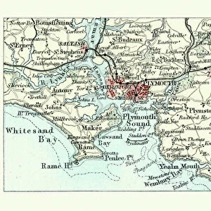
Fine Art Print : Map of Plymouth Sound and the Breakwater, Victorian 19th Century


![]()
Fine Art Prints From Fine Art Storehouse
Map of Plymouth Sound and the Breakwater, Victorian 19th Century
Vintage engraving of Map of Plymouth Sound and the Breakwater, Victorian 19th Century
Unleash your creativity and transform your space into a visual masterpiece!
duncan1890
Media ID 19684261
© of Duncan P Walker
20"x16" (+3" Border) Fine Art Print
Step back in time with our exquisite Victorian-era Map of Plymouth Sound and The Breakwater fine art print by duncan1890 from the Media Storehouse collection. This stunning vintage engraving transports you to the 19th century with intricate detail and captivating accuracy. The map showcases the historic harbor of Plymouth Sound and its iconic breakwater, making it a must-have for history enthusiasts and those who appreciate the beauty of bygone eras. Add this timeless piece to your home or office decor and let the rich history of Plymouth come alive.
20x16 image printed on 26x22 Fine Art Rag Paper with 3" (76mm) white border. Our Fine Art Prints are printed on 300gsm 100% acid free, PH neutral paper with archival properties. This printing method is used by museums and art collections to exhibit photographs and art reproductions.
Our fine art prints are high-quality prints made using a paper called Photo Rag. This 100% cotton rag fibre paper is known for its exceptional image sharpness, rich colors, and high level of detail, making it a popular choice for professional photographers and artists. Photo rag paper is our clear recommendation for a fine art paper print. If you can afford to spend more on a higher quality paper, then Photo Rag is our clear recommendation for a fine art paper print.
Estimated Image Size (if not cropped) is 35.9cm x 50.8cm (14.1" x 20")
Estimated Product Size is 55.9cm x 66cm (22" x 26")
These are individually made so all sizes are approximate
Artwork printed orientated as per the preview above, with portrait (vertical) orientation to match the source image.
FEATURES IN THESE COLLECTIONS
> Maps and Charts
> Related Images
> Fine Art Storehouse
> Map
> Historical Maps
EDITORS COMMENTS
This vintage engraving takes us back to the Victorian era, offering a glimpse into the maritime history of Plymouth Sound and its iconic Breakwater. The intricate details and delicate lines of this 19th-century map transport us to a time when exploration and trade were at their peak. Plymouth Sound, nestled on England's southern coast, has long been an important naval base and trading hub. This print showcases the sound's strategic location with precision, highlighting its natural harbor that has sheltered countless ships throughout history. The carefully etched contours reveal the undulating coastline, while small symbols denote lighthouses, buoys, and other navigational aids that guided sailors through these treacherous waters. The focal point of this artwork is undoubtedly the Breakwater—a monumental engineering feat constructed during Queen Victoria's reign. Jutting out into the sea for nearly a mile, it provided protection from storms and created a safe haven for vessels seeking refuge in Plymouth Sound. Its construction was no easy task; however, this map immortalizes its completion as a testament to human ingenuity. As we gaze upon this print by duncan1890 from Fine Art Storehouse, we are reminded of how art can preserve historical moments forever. It allows us to appreciate not only the beauty of nature but also mankind's triumphs over adversity. Whether you are an avid historian or simply captivated by nautical charm, this exquisite piece will transport you back in time to experience Plymouth Sound as it once was—an essential part of
MADE IN THE USA
Safe Shipping with 30 Day Money Back Guarantee
FREE PERSONALISATION*
We are proud to offer a range of customisation features including Personalised Captions, Color Filters and Picture Zoom Tools
SECURE PAYMENTS
We happily accept a wide range of payment options so you can pay for the things you need in the way that is most convenient for you
* Options may vary by product and licensing agreement. Zoomed Pictures can be adjusted in the Basket.