Fine Art Print > Maps and Charts > Related Images
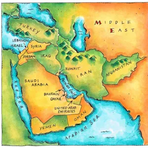
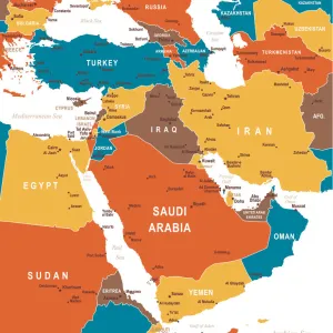
Fine Art Print : Map of Middle East - illustration


Resolution may be reduced at this size (119 DPI)
![]()
Fine Art Prints From Fine Art Storehouse
Map of Middle East - illustration
Colored Map of Middle East Asia with Country Names and Capital Cities
Unleash your creativity and transform your space into a visual masterpiece!
Media ID 13880195
20"x16" (+3" Border) Fine Art Print
20x16 image printed on 26x22 Fine Art Rag Paper with 3" (76mm) white border. Our Fine Art Prints are printed on 300gsm 100% acid free, PH neutral paper with archival properties. This printing method is used by museums and art collections to exhibit photographs and art reproductions.
Our fine art prints are high-quality prints made using a paper called Photo Rag. This 100% cotton rag fibre paper is known for its exceptional image sharpness, rich colors, and high level of detail, making it a popular choice for professional photographers and artists. Photo rag paper is our clear recommendation for a fine art paper print. If you can afford to spend more on a higher quality paper, then Photo Rag is our clear recommendation for a fine art paper print.
Estimated Image Size (if not cropped) is 40.6cm x 47.4cm (16" x 18.7")
Estimated Product Size is 55.9cm x 66cm (22" x 26")
These are individually made so all sizes are approximate
Artwork printed orientated as per the preview above, with portrait (vertical) orientation to match the source image.
FEATURES IN THESE COLLECTIONS
> Maps and Charts
> Related Images
> Fine Art Storehouse
> Map
> Historical Maps
MADE IN THE USA
Safe Shipping with 30 Day Money Back Guarantee
FREE PERSONALISATION*
We are proud to offer a range of customisation features including Personalised Captions, Color Filters and Picture Zoom Tools
SECURE PAYMENTS
We happily accept a wide range of payment options so you can pay for the things you need in the way that is most convenient for you
* Options may vary by product and licensing agreement. Zoomed Pictures can be adjusted in the Basket.