Fine Art Print > North America > United States of America > New York > New York > Maps
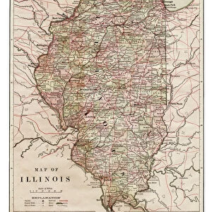
Fine Art Print : Map of Illinois 1894


![]()
Fine Art Prints From Fine Art Storehouse
Map of Illinois 1894
Johnsons Universal Cyclopedia - Volume IV New York - A. J. Johnson Company 1894
Unleash your creativity and transform your space into a visual masterpiece!
THEPALMER
Media ID 18356771
20"x16" (+3" Border) Fine Art Print
Discover the rich history of Illinois with this exquisite fine art print from Media Storehouse. Featuring the detailed and intricately designed Map of Illinois from the 1894 edition of Johnsons Universal Cyclopedia by THEPALMER, this print is a stunning addition to any home or office. With its antique charm and intricate cartography, this vintage map transports you back in time, making it a unique and captivating conversation starter. Bring a piece of the past into your present with this beautiful fine art print from Media Storehouse.
20x16 image printed on 26x22 Fine Art Rag Paper with 3" (76mm) white border. Our Fine Art Prints are printed on 300gsm 100% acid free, PH neutral paper with archival properties. This printing method is used by museums and art collections to exhibit photographs and art reproductions.
Our fine art prints are high-quality prints made using a paper called Photo Rag. This 100% cotton rag fibre paper is known for its exceptional image sharpness, rich colors, and high level of detail, making it a popular choice for professional photographers and artists. Photo rag paper is our clear recommendation for a fine art paper print. If you can afford to spend more on a higher quality paper, then Photo Rag is our clear recommendation for a fine art paper print.
Estimated Image Size (if not cropped) is 35.5cm x 50.8cm (14" x 20")
Estimated Product Size is 55.9cm x 66cm (22" x 26")
These are individually made so all sizes are approximate
Artwork printed orientated as per the preview above, with portrait (vertical) orientation to match the source image.
FEATURES IN THESE COLLECTIONS
> Maps and Charts
> Related Images
> North America
> United States of America
> New York
> New York
> Maps
> North America
> United States of America
> New York
> Related Images
Map of Illinois 1894 - A Glimpse into the Past
EDITORS COMMENTS
. Step back in time with this photo print, showcasing a meticulously detailed "Map of Illinois 1894". Transporting us to an era long gone, this vintage piece offers a fascinating glimpse into the state's rich history. Originally featured in Johnsons Universal Cyclopedia - Volume IV New York by A. J. Johnson Company in 1894, this map captures the essence of cartographic artistry from over a century ago. The intricate details and delicate craftsmanship make it a true collector's item for history enthusiasts and lovers of fine art alike. Every line and contour on this map tells a story, revealing towns, cities, rivers, and railroads that were integral to Illinois' development during that period. It serves as both an educational tool and an aesthetic delight for those who appreciate the beauty found within historical documents. The expertise behind THEPALMER's restoration work has breathed new life into this antique gem while preserving its authenticity. With vibrant colors and crisp lines carefully brought out through meticulous digital enhancement techniques, each print is crafted to perfection. Whether you are an admirer of vintage maps or simply wish to adorn your space with unique artwork that sparks conversation, "Map of Illinois 1894" will undoubtedly captivate all who lay eyes upon it. Let it transport you back to a bygone era where exploration was at its peak and marvel at the wonders waiting to be discovered within its borders
MADE IN THE USA
Safe Shipping with 30 Day Money Back Guarantee
FREE PERSONALISATION*
We are proud to offer a range of customisation features including Personalised Captions, Color Filters and Picture Zoom Tools
SECURE PAYMENTS
We happily accept a wide range of payment options so you can pay for the things you need in the way that is most convenient for you
* Options may vary by product and licensing agreement. Zoomed Pictures can be adjusted in the Basket.