Fine Art Print > Oceania > Australia > Maps
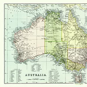
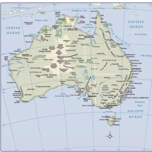
Fine Art Print : Map of Australia 1900


![]()
Fine Art Prints From Fine Art Storehouse
Map of Australia 1900
Meyers hand-Atlas Leipzig und Wien Verlag des Bibliographischen Instituts 1900
Unleash your creativity and transform your space into a visual masterpiece!
THEPALMER
Media ID 18106849
© 2014 Roberto Adrian Photography
20"x16" (+3" Border) Fine Art Print
Discover the rich history of Australia with this stunning Fine Art Print from Media Storehouse. Featuring the intricately detailed Map of Australia from THEPALMER's 1900 edition of Meyers Hand-Atlas, published by the Bibliographisches Institut in Leipzig and Wien. This vintage map transports you back in time, offering a captivating glimpse into the cartographic record of our continent's past. Add an air of historical charm to your space with this exquisite piece of decorative art.
20x16 image printed on 26x22 Fine Art Rag Paper with 3" (76mm) white border. Our Fine Art Prints are printed on 300gsm 100% acid free, PH neutral paper with archival properties. This printing method is used by museums and art collections to exhibit photographs and art reproductions.
Our fine art prints are high-quality prints made using a paper called Photo Rag. This 100% cotton rag fibre paper is known for its exceptional image sharpness, rich colors, and high level of detail, making it a popular choice for professional photographers and artists. Photo rag paper is our clear recommendation for a fine art paper print. If you can afford to spend more on a higher quality paper, then Photo Rag is our clear recommendation for a fine art paper print.
Estimated Image Size (if not cropped) is 49.6cm x 40.6cm (19.5" x 16")
Estimated Product Size is 66cm x 55.9cm (26" x 22")
These are individually made so all sizes are approximate
Artwork printed orientated as per the preview above, with landscape (horizontal) orientation to match the source image.
FEATURES IN THESE COLLECTIONS
> Oceania
> Australia
> Related Images
> Fine Art Storehouse
> Map
> Historical Maps
EDITORS COMMENTS
In this print titled "Map of Australia 1900" we are transported back in time to the turn of the century. The map, originally published in Meyers Hand-Atlas Leipzig und Wien Verlag des Bibliographischen Instituts in 1900, offers a fascinating glimpse into the geographical landscape and political divisions of Australia during that era. The intricate details and delicate craftsmanship displayed on this vintage map truly make it a work of art. Every contour line, river system, and mountain range is meticulously depicted, showcasing the immense beauty and diversity found across the continent. As our eyes wander over its surface, we can almost feel ourselves embarking on an exploratory journey through uncharted territories. This particular print by THEPALMER captures not only the historical significance but also evokes a sense of nostalgia for a bygone era. It serves as a reminder of how far we have come since then while honoring the rich heritage and cultural tapestry that defines Australia today. Whether you are an avid collector or simply appreciate fine art, this exquisite print from Fine Art Storehouse is sure to be a cherished addition to any space. Its timeless appeal invites us to reflect upon our past while inspiring curiosity about what lies ahead for this vast land down under.
MADE IN THE USA
Safe Shipping with 30 Day Money Back Guarantee
FREE PERSONALISATION*
We are proud to offer a range of customisation features including Personalised Captions, Color Filters and Picture Zoom Tools
SECURE PAYMENTS
We happily accept a wide range of payment options so you can pay for the things you need in the way that is most convenient for you
* Options may vary by product and licensing agreement. Zoomed Pictures can be adjusted in the Basket.