Fine Art Print > Europe > United Kingdom > England > Greater Manchester > Manchester
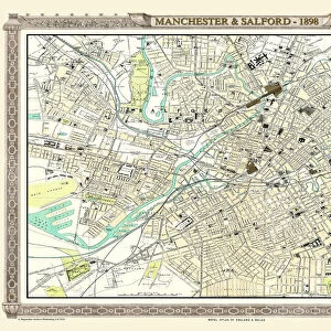
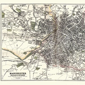
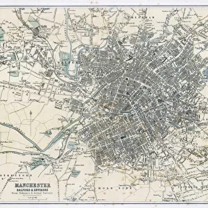
Fine Art Print : Antique map, Manchester, England, 19th Century


![]()
Fine Art Prints from Fine Art Storehouse
Antique map, Manchester, England, 19th Century
Vintage engraving of a Antique map, Manchester, England, 19th Century
Unleash your creativity and transform your space into a visual masterpiece!
duncan1890
Media ID 15107367
© This content is subject to copyright
1890s Colour Colours Equipment Great Britain Image Created 1890 1899 Manchester Navigational Equipment North West England Northern Europe Retro Road Map Styles Supplies United Kingdom Victorian Greater Manchester Obsolete
20"x16" (+3" Border) Fine Art Print
Step back in time with our exquisite antique map of Manchester, England, from the Fine Art Storehouse collection. This vintage engraving, created in the 19th century by the talented artist duncan1890, offers a captivating glimpse into the past. The intricate details and rich colors bring the history of Manchester to life, making this a stunning addition to any home or office. Perfect for history enthusiasts, map collectors, or those who appreciate the beauty of vintage art, this fine art print is sure to be a conversation starter and a cherished piece in your personal collection.
20x16 image printed on 26x22 Fine Art Rag Paper with 3" (76mm) white border. Our Fine Art Prints are printed on 300gsm 100% acid free, PH neutral paper with archival properties. This printing method is used by museums and art collections to exhibit photographs and art reproductions.
Our fine art prints are high-quality prints made using a paper called Photo Rag. This 100% cotton rag fibre paper is known for its exceptional image sharpness, rich colors, and high level of detail, making it a popular choice for professional photographers and artists. Photo rag paper is our clear recommendation for a fine art paper print. If you can afford to spend more on a higher quality paper, then Photo Rag is our clear recommendation for a fine art paper print.
Estimated Image Size (if not cropped) is 40.6cm x 50.8cm (16" x 20")
Estimated Product Size is 55.9cm x 66cm (22" x 26")
These are individually made so all sizes are approximate
Artwork printed orientated as per the preview above, with portrait (vertical) orientation to match the source image.
FEATURES IN THESE COLLECTIONS
> Europe
> Related Images
> Europe
> United Kingdom
> England
> Greater Manchester
> Manchester
> Europe
> United Kingdom
> England
> Manchester
> Manchester
> Europe
> United Kingdom
> England
> Maps
> Europe
> United Kingdom
> England
> Paintings
> Europe
> United Kingdom
> England
> Posters
> Europe
> United Kingdom
> England
> Related Images
> Europe
> United Kingdom
> Related Images
> Historic
> Historical fashion trends
> Victorian fashion trends
> Historic
> Victorian era fashion
> Fine Art Storehouse
> Map
> Historical Maps
EDITORS COMMENTS
This vintage engraving takes us back in time to the 19th century, showcasing an antique map of Manchester, England. The intricate details and vibrant colors bring this piece of cartography to life, revealing a snapshot of history that is both fascinating and nostalgic. The map itself was created in the 1890s, offering a glimpse into the past when navigational equipment was still rudimentary and road maps were essential for travelers. It captures the essence of Victorian England with its old-fashioned charm and elegant style. As we study this lithograph closely, we can appreciate the artistry involved in its creation. The careful engravings depict every street and landmark with precision, providing a visual guide to Greater Manchester and its surroundings. This print serves as a testament to the craftsmanship of yesteryears' illustrators who meticulously crafted such detailed images. Transporting us back to Northern Europe during this bygone era, it allows us to reflect on how much has changed since then. With modern technology rendering these types of maps obsolete today, this print becomes even more valuable as a historical artifact. Duncan1890's photograph perfectly captures all these elements - from the faded colors that evoke nostalgia for times gone by to the delicate lines that tell stories untold. It invites viewers on a journey through time while appreciating Manchester's rich history within their own homes or offices.
MADE IN THE USA
Safe Shipping with 30 Day Money Back Guarantee
FREE PERSONALISATION*
We are proud to offer a range of customisation features including Personalised Captions, Color Filters and Picture Zoom Tools
SECURE PAYMENTS
We happily accept a wide range of payment options so you can pay for the things you need in the way that is most convenient for you
* Options may vary by product and licensing agreement. Zoomed Pictures can be adjusted in the Cart.