Fine Art Print > North America > Canada > Maps
Fine Art Print : Antique Map of Canada - 19th Century


![]()
Fine Art Prints from Fine Art Storehouse
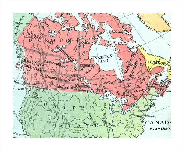
Antique Map of Canada - 19th Century
Vintage map of Canada at the end of the 19th century. Vintage etching circa late 19th century
Unleash your creativity and transform your space into a visual masterpiece!
powerofforever
Media ID 15149715
© This content is subject to copyright
20"x16" (+3" Border) Fine Art Print
Step back in time with our exquisite Antique Map of Canada from the Fine Art Storehouse. This stunning 19th century etching transports you to a bygone era, offering a captivating glimpse into the historical geography of Canada during the late 1800s. With intricate detail and vintage charm, this fine art print is not just a decorative piece, but a window into the past. Bring history to life in your home or office with the timeless beauty of our Antique Map of Canada from the Fine Art Storehouse.
20x16 image printed on 26x22 Fine Art Rag Paper with 3" (76mm) white border. Our Fine Art Prints are printed on 300gsm 100% acid free, PH neutral paper with archival properties. This printing method is used by museums and art collections to exhibit photographs and art reproductions.
Our fine art prints are high-quality prints made using a paper called Photo Rag. This 100% cotton rag fibre paper is known for its exceptional image sharpness, rich colors, and high level of detail, making it a popular choice for professional photographers and artists. Photo rag paper is our clear recommendation for a fine art paper print. If you can afford to spend more on a higher quality paper, then Photo Rag is our clear recommendation for a fine art paper print.
Estimated Image Size (if not cropped) is 50.8cm x 40.6cm (20" x 16")
Estimated Product Size is 66cm x 55.9cm (26" x 22")
These are individually made so all sizes are approximate
Artwork printed orientated as per the preview above, with landscape (horizontal) orientation to match the source image.
FEATURES IN THESE COLLECTIONS
> Maps and Charts
> Related Images
> North America
> Canada
> Maps
> North America
> Canada
> Related Images
> Fine Art Storehouse
> Map
> Historical Maps
EDITORS COMMENTS
This print transports us back in time to the late 19th century, showcasing an antique map of Canada. With its vintage etching style, this piece exudes a sense of nostalgia and historical significance. The intricately detailed map offers a glimpse into the territorial landscape of Canada during this era. As we gaze upon this remarkable artwork, we are reminded of the vastness and diversity that defines Canada's geography. From coast to coast, every province and territory is meticulously depicted on this map, allowing us to appreciate the immense size and beauty of this great nation. The fine lines and delicate shading used in creating this vintage masterpiece evoke a sense of craftsmanship rarely seen in modern cartography. It serves as a testament to the artistry involved in mapping out uncharted territories during an age when exploration was at its peak. Whether you are a history enthusiast or simply captivated by the allure of vintage aesthetics, "Antique Map of Canada - 19th Century" will undoubtedly be an exquisite addition to your collection. This print invites you to embark on a journey through time, offering glimpses into our past while celebrating the rich heritage that has shaped present-day Canada.
MADE IN THE USA
Safe Shipping with 30 Day Money Back Guarantee
FREE PERSONALISATION*
We are proud to offer a range of customisation features including Personalised Captions, Color Filters and Picture Zoom Tools
SECURE PAYMENTS
We happily accept a wide range of payment options so you can pay for the things you need in the way that is most convenient for you
* Options may vary by product and licensing agreement. Zoomed Pictures can be adjusted in the Cart.