Fine Art Print > Europe > France > Canton > Maine
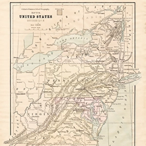
Fine Art Print : USA New England states map 1875


![]()
Fine Art Prints From Fine Art Storehouse
USA New England states map 1875
The Independent Course Comprehensive Geography by James Monteith, A.S. Barnes & Co, New York & Chicago 1875
Unleash your creativity and transform your space into a visual masterpiece!
THEPALMER
Media ID 13612175
© This content is subject to copyright
Connecticut Globe Navigational Equipment Maine Massachusetts New England New England Usa New Hampshire Paper Rhode Island Vermont Drawing Art Product
20"x16" (+3" Border) Fine Art Print
Step back in time with our exquisite fine art print of a vintage USA New England States Map from 1875, by THEPALMER. This captivating piece is taken from The Independent Course in Comprehensive Geography by James Monteith, published by A.S. Barnes & Co, New York & Chicago. Add an air of history and sophistication to your home or office with this beautifully detailed and intricately designed map, showcasing the New England region as it appeared over a century ago. A perfect addition to any room, this fine art print is sure to ignite conversation and inspire a sense of wonder about the past.
20x16 image printed on 26x22 Fine Art Rag Paper with 3" (76mm) white border. Our Fine Art Prints are printed on 300gsm 100% acid free, PH neutral paper with archival properties. This printing method is used by museums and art collections to exhibit photographs and art reproductions.
Our fine art prints are high-quality prints made using a paper called Photo Rag. This 100% cotton rag fibre paper is known for its exceptional image sharpness, rich colors, and high level of detail, making it a popular choice for professional photographers and artists. Photo rag paper is our clear recommendation for a fine art paper print. If you can afford to spend more on a higher quality paper, then Photo Rag is our clear recommendation for a fine art paper print.
Estimated Image Size (if not cropped) is 40.6cm x 50.8cm (16" x 20")
Estimated Product Size is 55.9cm x 66cm (22" x 26")
These are individually made so all sizes are approximate
Artwork printed orientated as per the preview above, with portrait (vertical) orientation to match the source image.
FEATURES IN THESE COLLECTIONS
> Europe
> France
> Canton
> Maine
> Europe
> United Kingdom
> England
> Hampshire
> Related Images
> Europe
> United Kingdom
> England
> Maps
> Europe
> United Kingdom
> England
> York
> Maps and Charts
> Related Images
> North America
> United States of America
> Connecticut
> Related Images
> North America
> United States of America
> Maine
> Related Images
> North America
> United States of America
> Maps
> North America
> United States of America
> Massachusetts
> Related Images
> North America
> United States of America
> New Hampshire
> Related Images
> Fine Art Storehouse
> The Magical World of Illustration
> Palmer Illustrated Collection
> Fine Art Storehouse
> Map
> Historical Maps
> Fine Art Storehouse
> Map
> USA Maps
EDITORS COMMENTS
This print takes us back in time to the year 1875, showcasing a detailed map of the New England states in the United States. The map is an exquisite piece from "The Independent Course Comprehensive Geography" by James Monteith, published by A. S. Barnes & Co in New York and Chicago. With its vertical orientation, this vintage artwork captures the essence of a bygone era. The intricate engravings and etchings on paper bring forth a sense of nostalgia and appreciation for traditional cartography techniques. It serves as a testament to the artistry involved in creating maps before modern technology took over. The map encompasses Connecticut, Rhode Island, Maine, Massachusetts, Vermont, and New Hampshire - all part of the charming region known as New England. Its purpose was to educate readers about physical geography while providing navigational information through globes and other tools. As we gaze upon this antique masterpiece created more than 145 years ago, it transports us back to an era where exploration and discovery were at their peak. It reminds us of how far we have come since then while also appreciating the beauty that lies within historical artifacts like this one. "The USA New England states map 1875" is not just a drawing or illustration; it represents our connection with history and our fascination with old-world craftsmanship. This remarkable piece curated by THEPALMER brings together art enthusiasts who appreciate both fine art products and historical significance without mentioning any commercial use associated with it.
MADE IN THE USA
Safe Shipping with 30 Day Money Back Guarantee
FREE PERSONALISATION*
We are proud to offer a range of customisation features including Personalised Captions, Color Filters and Picture Zoom Tools
SECURE PAYMENTS
We happily accept a wide range of payment options so you can pay for the things you need in the way that is most convenient for you
* Options may vary by product and licensing agreement. Zoomed Pictures can be adjusted in the Basket.