Fine Art Print > Fine Art Finder > Schools > English School
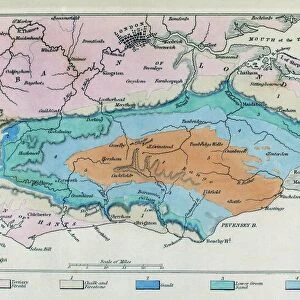
Fine Art Print : Map of Oxford, England, 12th to 13th century, from A Short History of the English


Please select a smaller print size for this image
![]()
Fine Art Prints From Fine Art Finder
Map of Oxford, England, 12th to 13th century, from A Short History of the English
KW392538 Map of Oxford, England, 12th to 13th century, from A Short History of the English People by J. R. Green, published 1893 (litho) by English School, (19th century); Private Collection; Ken Welsh; English, out of copyright
Media ID 12871972
© www.bridgemanimages.com
20"x16" (+3" Border) Fine Art Print
Step back in time with our exquisite Map of Oxford, England from the 12th to 13th century. This fine art print, sourced from A Short History of the English People by J.R. Green, offers a captivating glimpse into the past. Meticulously preserved and expertly reproduced, this intricate map showcases the layout of Oxford during a pivotal period in its history. Add an air of historical sophistication to your space with this stunning addition to your art collection.
20x16 image printed on 26x22 Fine Art Rag Paper with 3" (76mm) white border. Our Fine Art Prints are printed on 300gsm 100% acid free, PH neutral paper with archival properties. This printing method is used by museums and art collections to exhibit photographs and art reproductions.
Our fine art prints are high-quality prints made using a paper called Photo Rag. This 100% cotton rag fibre paper is known for its exceptional image sharpness, rich colors, and high level of detail, making it a popular choice for professional photographers and artists. Photo rag paper is our clear recommendation for a fine art paper print. If you can afford to spend more on a higher quality paper, then Photo Rag is our clear recommendation for a fine art paper print.
Estimated Image Size (if not cropped) is 50.8cm x 40.6cm (20" x 16")
Estimated Product Size is 66cm x 55.9cm (26" x 22")
These are individually made so all sizes are approximate
Artwork printed orientated as per the preview above, with landscape (horizontal) orientation to match the source image.
EDITORS COMMENTS
This print takes us back in time to the 12th and 13th centuries, as we explore a meticulously detailed map of Oxford, England. A true treasure from J. R. Green's renowned publication "A Short History of the English People" this lithograph captures the essence of medieval cartography. Every inch of this map is filled with historical significance, offering a glimpse into the city's rich past. The intricate streets wind their way through the illustration, revealing a bustling urban center that has evolved over centuries. As our eyes trace along these ancient pathways, we can almost imagine ourselves walking through history. The River Isis (known today as the Thames) gracefully meanders through Oxford, adding an enchanting touch to this visual masterpiece. Its presence reminds us of how waterways have always played a crucial role in shaping cities and fostering trade and communication. This print not only showcases exceptional craftsmanship but also serves as a valuable resource for historians and enthusiasts alike. It allows us to study and appreciate the architectural evolution of one of England's most iconic cities. As we delve into every minute detail captured on this map – from its buildings to its bridges – we are transported back in time, immersing ourselves in Oxford's vibrant past. This extraordinary piece invites us to marvel at how much has changed while recognizing that some elements still endure within this historic cityscape.
MADE IN THE USA
Safe Shipping with 30 Day Money Back Guarantee
FREE PERSONALISATION*
We are proud to offer a range of customisation features including Personalised Captions, Color Filters and Picture Zoom Tools
SECURE PAYMENTS
We happily accept a wide range of payment options so you can pay for the things you need in the way that is most convenient for you
* Options may vary by product and licensing agreement. Zoomed Pictures can be adjusted in the Basket.