Fine Art Print > Fine Art Finder > Maps (celestial & Terrestrial)
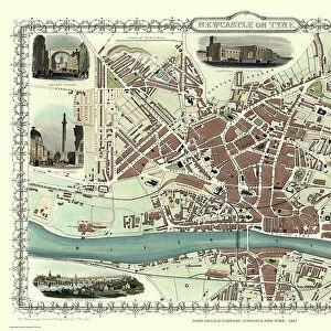
Fine Art Print : Map of Oxford, 1643 (engraving) (b / w photo)
 (b / w photo)")


![]()
Fine Art Prints from Fine Art Finder
Map of Oxford, 1643 (engraving) (b / w photo)
XJF270067 Map of Oxford, 1643 (engraving) (b/w photo) by Hollar, Wenceslaus (1607-77); Private Collection; Czech, out of copyright
Media ID 12783161
© www.bridgemanart.com
Aerial View Colleges Compass Index
20"x16" (+3" Border) Fine Art Print
Discover the rich history of Oxford with this exquisite Map of Oxford, 1643 from the Media Storehouse Fine Art Prints collection. This intricately detailed engraving, created by the renowned artist Wenceslaus Hollar, offers a fascinating glimpse into the past. The black and white image captures the layout of the city as it existed over 350 years ago, complete with its medieval walls, colleges, and key landmarks. Bring a piece of historical Oxford into your home or office with this beautiful, museum-quality print.
20x16 image printed on 26x22 Fine Art Rag Paper with 3" (76mm) white border. Our Fine Art Prints are printed on 300gsm 100% acid free, PH neutral paper with archival properties. This printing method is used by museums and art collections to exhibit photographs and art reproductions.
Our fine art prints are high-quality prints made using a paper called Photo Rag. This 100% cotton rag fibre paper is known for its exceptional image sharpness, rich colors, and high level of detail, making it a popular choice for professional photographers and artists. Photo rag paper is our clear recommendation for a fine art paper print. If you can afford to spend more on a higher quality paper, then Photo Rag is our clear recommendation for a fine art paper print.
Estimated Image Size (if not cropped) is 50.8cm x 40.6cm (20" x 16")
Estimated Product Size is 66cm x 55.9cm (26" x 22")
These are individually made so all sizes are approximate
Artwork printed orientated as per the preview above, with landscape (horizontal) orientation to match the source image.
FEATURES IN THESE COLLECTIONS
> Fine Art Finder
> Artists
> Wenceslaus Hollar
> Fine Art Finder
> Maps (celestial & Terrestrial)
EDITORS COMMENTS
This print takes us back in time to the year 1643, showcasing a meticulously detailed engraving of the Map of Oxford. Created by Wenceslaus Hollar, a renowned Czech artist from the 17th century, this piece is now part of a private collection. The map offers an aerial view of Oxford, providing a fascinating glimpse into the city's layout during that era. With its intricate index and clearly marked streets, it serves as both a navigational tool and historical artifact. The presence of numerous colleges indicates Oxford's long-standing reputation as an esteemed center for education and learning. A compass elegantly adorns one corner of the map, reminding us of the importance placed on accurate direction in those times. Additionally, we can spot the coat of arms representing Oxford University - an emblem synonymous with knowledge and intellectual pursuit. As we delve into this mesmerizing artwork, let us appreciate not only its artistic value but also its ability to transport us back centuries ago. It allows us to envision how life may have unfolded within these historic walls while marveling at Hollar's skillful craftsmanship.
MADE IN THE USA
Safe Shipping with 30 Day Money Back Guarantee
FREE PERSONALISATION*
We are proud to offer a range of customisation features including Personalised Captions, Color Filters and Picture Zoom Tools
SECURE PAYMENTS
We happily accept a wide range of payment options so you can pay for the things you need in the way that is most convenient for you
* Options may vary by product and licensing agreement. Zoomed Pictures can be adjusted in the Cart.