Fine Art Print > Africa > Algeria > Maps
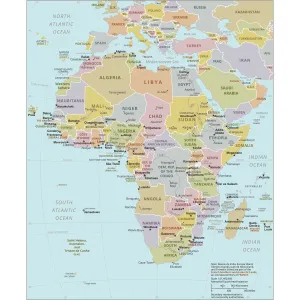
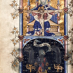
Fine Art Print : Department of Algiers, French Algeria - France and its Colonies. Atlas illustrates one hundred and five maps from the maps of the depot of war, bridges and footwear and the Navy by M. VUILLEMIN. 1876

![]()
Fine Art Prints From Fine Art Finder
Department of Algiers, French Algeria - France and its Colonies. Atlas illustrates one hundred and five maps from the maps of the depot of war, bridges and footwear and the Navy by M. VUILLEMIN. 1876
XEE4144398 Department of Algiers, French Algeria - France and its Colonies. Atlas illustrates one hundred and five maps from the maps of the depot of war, bridges and footwear and the Navy by M. VUILLEMIN. 1876. by Vuillemin, Alexandre (1812-1886); Private Collection; (add.info.: Department of Algiers, French Algeria - France and its Colonies. Atlas illustrates one hundred and five maps from the maps of the depot of war, bridges and footwear and the Navy by M. VUILLEMIN. 1876.); Stefano Bianchetti
Media ID 25153680
© Stefano Bianchetti / Bridgeman Images
Algeria Algeria Algerian Algerian Algerians Algerie Arabs Atlas Book City Map City Plan Du Soudan General Map Maghrebin Maghrebine North East Africa North West Africa Northafrica Street Plan Arab Civilization Arab Culture Arabians Central Africa Geographical Map Maghreb Maghrebi Maghrebian Sudan
21"x14" (+3" Border) Fine Art Print
Step back in time with our exquisite Fine Art Print of the Department of Algiers, French Algeria - France and its Colonies. Atlas. This captivating print, from the collection of Fine Art Finder, showcases an intricately detailed map illustration by M. VUILLEMIN, published in 1876. With one hundred and five maps from the depots of war, bridges, and footwear, and the Navy, this vintage atlas is a must-have for history enthusiasts and art collectors alike. Experience the rich history of French Algeria through the stunning visuals of this timeless piece. Add a touch of history and elegance to your home or office with this beautiful Fine Art Print.
21x14 image printed on 27x20 Fine Art Rag Paper with 3" (76mm) white border. Our Fine Art Prints are printed on 300gsm 100% acid free, PH neutral paper with archival properties. This printing method is used by museums and art collections to exhibit photographs and art reproductions.
Our fine art prints are high-quality prints made using a paper called Photo Rag. This 100% cotton rag fibre paper is known for its exceptional image sharpness, rich colors, and high level of detail, making it a popular choice for professional photographers and artists. Photo rag paper is our clear recommendation for a fine art paper print. If you can afford to spend more on a higher quality paper, then Photo Rag is our clear recommendation for a fine art paper print.
Estimated Image Size (if not cropped) is 35.5cm x 53.3cm (14" x 21")
Estimated Product Size is 50.8cm x 68.6cm (20" x 27")
These are individually made so all sizes are approximate
Artwork printed orientated as per the preview above, with portrait (vertical) orientation to match the source image.
FEATURES IN THESE COLLECTIONS
> Africa
> Algeria
> Related Images
> Africa
> Sudan
> Related Images
> Maps and Charts
> Related Images
EDITORS COMMENTS
This print showcases a historical artifact from the late 19th century - an atlas titled "Department of Algiers, French Algeria - France and its Colonies". Created by Alexandre Vuillemin in 1876, this remarkable piece features one hundred and five maps sourced from the depot of war, bridges and footwear, as well as the Navy. The intricate engravings depict various regions within North Africa, specifically focusing on French colonial territories. The atlas provides a comprehensive geographical overview of Algeria and its surrounding areas during this period of intense colonialism. It offers insights into the political boundaries, topography, and infrastructure networks that shaped these regions under French rule. The attention to detail is evident in each map's precision and accuracy. Stefano Bianchetti's expert photography captures the essence of this rare find with vibrant colors that bring life to every page. This particular image highlights a section showcasing Algerian cities' street plans, providing viewers with a glimpse into urban life at that time. As we reflect upon history through this photo print, it serves as a reminder of how colonial powers like France sought to expand their influence across continents. It also prompts us to consider the impact such colonization had on indigenous populations and their cultures. Overall, this photograph invites us to explore not only the beauty but also the complex narratives embedded within historical artifacts like Vuillemin's atlas.
MADE IN THE USA
Safe Shipping with 30 Day Money Back Guarantee
FREE PERSONALISATION*
We are proud to offer a range of customisation features including Personalised Captions, Color Filters and Picture Zoom Tools
SECURE PAYMENTS
We happily accept a wide range of payment options so you can pay for the things you need in the way that is most convenient for you
* Options may vary by product and licensing agreement. Zoomed Pictures can be adjusted in the Basket.