Fine Art Print > Europe > United Kingdom > Northern Ireland > Maps
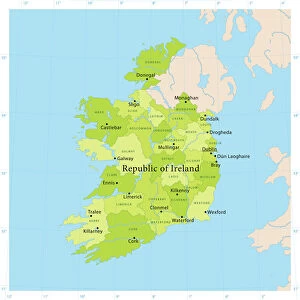
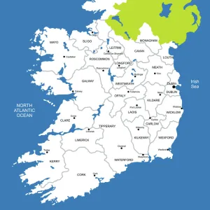
Fine Art Print : Irish Free State And Northern Ireland. From Bacons Excelsior Atlas Of The World, Published Circa 1930


![]()
Fine Art Prints from Design Pics
Irish Free State And Northern Ireland. From Bacons Excelsior Atlas Of The World, Published Circa 1930
Design Pics offers Distinctively Different Imagery representing over 1,500 contributors
Media ID 18191538
© Ken Welsh / Design Pics
Atlas Between Cartography First Free Irish North Northern Second State Wars World
20"x16" (+3" Border) Fine Art Print
Step back in time with our exquisite Fine Art Print from Media Storehouse, featuring a captivating image of Irish Free State and Northern Ireland as depicted in the Bacons Excelsior Atlas of the World, published around 1930. This vintage map, captured by renowned photographer Ken Welsh from Design Pics, showcases historical cartography with intricate detail and authenticity. Add a touch of nostalgia and cultural heritage to your home or office decor with this beautiful and unique piece of art.
20x16 image printed on 26x22 Fine Art Rag Paper with 3" (76mm) white border. Our Fine Art Prints are printed on 300gsm 100% acid free, PH neutral paper with archival properties. This printing method is used by museums and art collections to exhibit photographs and art reproductions.
Our fine art prints are high-quality prints made using a paper called Photo Rag. This 100% cotton rag fibre paper is known for its exceptional image sharpness, rich colors, and high level of detail, making it a popular choice for professional photographers and artists. Photo rag paper is our clear recommendation for a fine art paper print. If you can afford to spend more on a higher quality paper, then Photo Rag is our clear recommendation for a fine art paper print.
Estimated Image Size (if not cropped) is 40.6cm x 50.8cm (16" x 20")
Estimated Product Size is 55.9cm x 66cm (22" x 26")
These are individually made so all sizes are approximate
Artwork printed orientated as per the preview above, with portrait (vertical) orientation to match the source image.
FEATURES IN THESE COLLECTIONS
> Europe
> Republic of Ireland
> Maps
> Europe
> United Kingdom
> Northern Ireland
> Maps
> Europe
> United Kingdom
> Northern Ireland
> Posters
> Europe
> United Kingdom
> Northern Ireland
> Related Images
> Historic
> World War I and II
> World War I
> Historic
> World War I and II
> World War II
> Maps and Charts
> Related Images
> Maps and Charts
> World
EDITORS COMMENTS
This print showcases a historical map titled "Irish Free State And Northern Ireland" from the renowned Bacons Excelsior Atlas Of The World, published around 1930. A true gem of cartography, this vintage piece offers a fascinating glimpse into the intricate geopolitical landscape of Ireland during that era. The map is divided into two distinct regions: Irish Free State and Northern Ireland. It beautifully illustrates the complex political dynamics that emerged after the First World War and subsequent conflicts in the region. With meticulous detail, it outlines borders, cities, rivers, and other geographical features with precision. As we delve into this remarkable artifact by Ken Welsh, we are transported back to a time when Ireland was grappling with its newfound independence and partitioned identity. The Irish Free State represented one part of the island's struggle for self-governance while Northern Ireland remained under British rule. This photograph print not only captures an important moment in history but also serves as a reminder of how maps can tell powerful stories about our world's past. It invites us to reflect on the impact of war and colonialism on nations' boundaries and people's lives. Whether you are an avid collector or simply intrigued by history, this extraordinary image will undoubtedly spark curiosity and ignite conversations about Ireland's rich heritage.
MADE IN THE USA
Safe Shipping with 30 Day Money Back Guarantee
FREE PERSONALISATION*
We are proud to offer a range of customisation features including Personalised Captions, Color Filters and Picture Zoom Tools
SECURE PAYMENTS
We happily accept a wide range of payment options so you can pay for the things you need in the way that is most convenient for you
* Options may vary by product and licensing agreement. Zoomed Pictures can be adjusted in the Cart.