Fine Art Print > Asia > Palestine > Maps
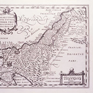
Fine Art Print : Ancient Palestine From The Citizens Atlas Of The World Published London Circa 1899

![]()
Fine Art Prints From Design Pics
Ancient Palestine From The Citizens Atlas Of The World Published London Circa 1899
Design Pics offers Distinctively Different Imagery representing over 1,500 contributors
Media ID 18189833
© Ken Welsh / Design Pics
Ancient Atlas Biblical Palestine Nineteenth
20"x20" (+3" Border) Fine Art Print
Step back in time with our exquisite Fine Art Print of Ancient Palestine from The Citizens Atlas Of The World, published in London circa 1899. This captivating vintage map, captured by Ken Welsh from Design Pics, transports you back to an era of rich history and cultural significance. The intricate details and authentic antique aesthetics make this print an exceptional addition to any home or office space. Bring history to life with this stunning piece of art that tells a story of a time long past.
21x7 image printed on 27x13 Fine Art Rag Paper with 3" (76mm) white border. Our Fine Art Prints are printed on 300gsm 100% acid free, PH neutral paper with archival properties. This printing method is used by museums and art collections to exhibit photographs and art reproductions.
Our fine art prints are high-quality prints made using a paper called Photo Rag. This 100% cotton rag fibre paper is known for its exceptional image sharpness, rich colors, and high level of detail, making it a popular choice for professional photographers and artists. Photo rag paper is our clear recommendation for a fine art paper print. If you can afford to spend more on a higher quality paper, then Photo Rag is our clear recommendation for a fine art paper print.
Estimated Image Size (if not cropped) is 17.7cm x 36.5cm (7" x 14.4")
Estimated Product Size is 33cm x 68.6cm (13" x 27")
These are individually made so all sizes are approximate
Artwork printed orientated as per the preview above, with portrait (vertical) orientation to match the source image.
FEATURES IN THESE COLLECTIONS
> Asia
> Palestine
> Related Images
> Maps and Charts
> Early Maps
> Maps and Charts
> Related Images
> Maps and Charts
> World
EDITORS COMMENTS
This print takes us back in time to the ancient land of Palestine, as depicted in the Citizens Atlas of the World published in London circa 1899. The intricate details and vibrant colors bring this nineteenth-century map to life, allowing us to explore a bygone era. As we gaze upon this vertical image, we are transported into biblical times, where history and mythology intertwine. The old world charm is evident in every inch of this century-old artwork. From its faded hues to its delicate lines, it exudes a sense of nostalgia that captivates our imagination. The map showcases the vastness and diversity of ancient Palestine with great precision. It reveals cities and settlements that have long been lost or transformed over time. Each corner holds secrets waiting to be discovered - from iconic landmarks like Jerusalem's Old City walls to lesser-known villages nestled amidst rolling hills. Ken Welsh has masterfully captured the essence of this historical artifact through his expert photography skills. His attention to detail allows us to appreciate not only the beauty but also the significance of such an atlas during its time. Whether you are a history enthusiast or simply intrigued by ancient civilizations, this print will transport you on a visual journey through centuries past. It serves as a reminder that even within modernity lies an enduring connection to our rich cultural heritage.
MADE IN THE USA
Safe Shipping with 30 Day Money Back Guarantee
FREE PERSONALISATION*
We are proud to offer a range of customisation features including Personalised Captions, Color Filters and Picture Zoom Tools
SECURE PAYMENTS
We happily accept a wide range of payment options so you can pay for the things you need in the way that is most convenient for you
* Options may vary by product and licensing agreement. Zoomed Pictures can be adjusted in the Basket.