Home > Europe > United Kingdom > Northern Ireland > Maps
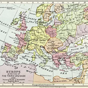
Map of Roman Britain c. 410. From Historical Atlas, published 1923 (print)
")
![]()
Wall Art and Photo Gifts from Fine Art Finder
Map of Roman Britain c. 410. From Historical Atlas, published 1923 (print)
2603520 Map of Roman Britain c. 410. From Historical Atlas, published 1923 (print)
Media ID 38172678
© Bridgeman Images
5 5th V Vth Century 5th 5th 5th V Vth Th Century 5th Century C5th Chart Countries Geographer Geographical Roman Civilisation Rule Unpopulated Vth Century
FEATURES IN THESE COLLECTIONS
> Europe
> Republic of Ireland
> Maps
> Europe
> United Kingdom
> England
> Maps
> Europe
> United Kingdom
> Heritage Sites
> Frontiers of the Roman Empire
> Europe
> United Kingdom
> Maps
> Europe
> United Kingdom
> Northern Ireland
> Maps
> Europe
> United Kingdom
> Northern Ireland
> Posters
> Europe
> United Kingdom
> Northern Ireland
> Related Images
> Fine Art Finder
> Temp Classification
> Historic
> Ancient civilizations
> Roman Empire
> Ancient Rome
> Historic
> Ancient civilizations
> Roman Empire
> Roman art
> Maps and Charts
> British Empire Maps
EDITORS COMMENTS
This stunning print of a Map of Roman Britain from around 410 AD offers a fascinating glimpse into the ancient world. Published in 1923 as part of a Historical Atlas, this colorful and detailed map showcases the extent of Roman influence in Britain during this pivotal period.
The intricate geography depicted on the map highlights key cities, roads, and territories that were under Roman control at the time. From Londinium to Eboracum, each location tells a story of conquest and civilization that shaped the landscape we see today.
As we study this map, we can imagine legions marching across rugged terrain, aqueducts bringing water to bustling towns, and villas dotting the countryside. The legacy of Roman rule is evident in every corner of Britain, from Hadrian's Wall in the north to the bustling port cities along the coast.
This print serves as both a historical document and a work of art, capturing the essence of an era long past with vivid colors and meticulous detail. It is a reminder of how far we have come since those ancient times while also honoring the enduring impact that Rome had on British culture and society.
MADE IN THE USA
Safe Shipping with 30 Day Money Back Guarantee
FREE PERSONALISATION*
We are proud to offer a range of customisation features including Personalised Captions, Color Filters and Picture Zoom Tools
SECURE PAYMENTS
We happily accept a wide range of payment options so you can pay for the things you need in the way that is most convenient for you
* Options may vary by product and licensing agreement. Zoomed Pictures can be adjusted in the Cart.