Home > Europe > United Kingdom > England > London > Museums > National Maritime Museum
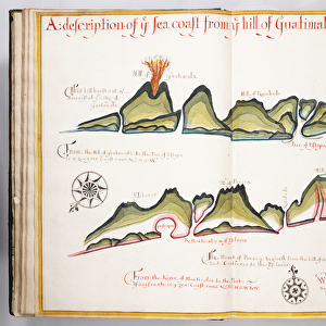
Chart of the English Channel and the Atlantic coasts of southern Britain and northern France, 1692 (coloured engraving)
")
![]()
Wall Art and Photo Gifts from Fine Art Finder
Chart of the English Channel and the Atlantic coasts of southern Britain and northern France, 1692 (coloured engraving)
7339354 Chart of the English Channel and the Atlantic coasts of southern Britain and northern France, 1692 (coloured engraving) by Sanson D'Abbeville, Nicolas (1600-67); 63x97 cm; National Maritime Museum, London, UK; (add.info.: Creator: Sanson, Nicolas; Jaillot
Single sheet. Engraving coloured in outline. Scale [circa1:850,000]. The scale is in marine leagues. This is a Mercator chart of the English Channel and the Atlantic coasts of southern Britain and northern France. It has borders graduated for latitude and longitude from the meridian of Ferro. Sandbanks and soundings are shown.
Inscribed 'Carte de la Manche faite par ordre du Roy pour le service des armees de mer. Revuee et corrigee par le Sr.Sanson a Paris chez Hubert Jaillot 1692.'
This chart was included in Jaillot's, Le Neptune Francois, published in 1693.); © National Maritime Museum, Greenwich, London
Media ID 38339650
© © National Maritime Museum, Greenwich, London / Bridgeman Images
Atlantic Atlantic Ocean British Channel Coast Line English Channel
FEATURES IN THESE COLLECTIONS
> Arts
> Artists
> H
> Hubert Hubert
> Europe
> France
> Canton
> Manche
> Europe
> France
> Paris
> Maps
> Europe
> Republic of Ireland
> Maps
> Europe
> United Kingdom
> England
> London
> Boroughs
> Greenwich
> Europe
> United Kingdom
> England
> London
> Museums
> British Museum
> Europe
> United Kingdom
> England
> London
> Museums
> Greenwich Heritage Centre
> Europe
> United Kingdom
> England
> London
> Museums
> National Maritime Museum
> Europe
> United Kingdom
> England
> London
> Sights
> British Museum
> Fine Art Finder
> Artists
> Nicolas Sanson D'Abbeville
> Fine Art Finder
> Artists
> William Hack
EDITORS COMMENTS
This stunning coloured engraving from 1692, titled "Chart of the English Channel and the Atlantic coasts of southern Britain and northern France," offers a fascinating glimpse into maritime navigation during the late 17th century. Created by Nicolas Sanson D'Abbeville, a renowned cartographer of his time, this intricate map showcases the detailed coastlines, sandbanks, soundings, and borders graduated for latitude and longitude.
Measuring 63x97 cm, this Mercator chart is not only a practical tool for sailors but also a work of art in its own right. The vibrant colours used to outline the land masses and waterways add an element of beauty to this utilitarian piece.
Inscribed with the words 'Carte de la Manche faite par ordre du Roy pour le service des armees de mer. Revuee et corrigee par le Sr.Sanson a Paris chez Hubert Jaillot 1692,' this chart was created under royal order for naval purposes. It was later included in Jaillot's publication "Le Neptune Francois" in 1693.
Now housed at the National Maritime Museum in London, UK, this historical print serves as a reminder of both the scientific advancements and artistic achievements of centuries past. It is a testament to human ingenuity and exploration that continues to inspire awe today.
MADE IN THE USA
Safe Shipping with 30 Day Money Back Guarantee
FREE PERSONALISATION*
We are proud to offer a range of customisation features including Personalised Captions, Color Filters and Picture Zoom Tools
SECURE PAYMENTS
We happily accept a wide range of payment options so you can pay for the things you need in the way that is most convenient for you
* Options may vary by product and licensing agreement. Zoomed Pictures can be adjusted in the Cart.