Home > Arts > Artists > H > Franz Hogenberg
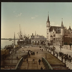
Map of Anvers (Antverpia), Belgique (etching, 1572-1617)
, Belgique (etching, 1572-1617)")
![]()
Wall Art and Photo Gifts from Fine Art Finder
Map of Anvers (Antverpia), Belgique (etching, 1572-1617)
LRI4707946 Map of Anvers (Antverpia), Belgique (etching, 1572-1617) by Hogenberg, Franz (1540-c.1590); Private Collection; (add.info.: Plan d Anvers (Antverpia), Belgique - Eau forte extraite de Civitates Orbis Terrarum (Atlas des villes du monde) de Georg Braun (1541-1622) et Franz Hogenberg (1540-1590), publie de 1572 a 1617 - Antwerp, Belgium - From " Civitates Orbis Terrarum" by G. Braun and F. Hogenberg, 1572-1617); Luisa Ricciarini; Netherlandish, out of copyright
Media ID 23328010
© Luisa Ricciarini / Bridgeman Images
16 16e 16eme Xvi Xvie Xvieme Siecle Antwerp Anvers Armoirie Atlas Book Belgique Belge Belges Blason Blazon Canal Carte Geographique Champ De Campagne Coat Of Arm Flamande Region Flemish Region Fleuve Fortification Geographical Map Geographie Vue D Une Ville Vue Dune Ville Vue Exterieure Exterior View Gravure
FEATURES IN THESE COLLECTIONS
> Arts
> Artists
> H
> Franz Hogenberg
> Europe
> Belgium
> Related Images
> Fine Art Finder
> Artists
> Franz Hogenberg
> Fine Art Finder
> Artists
> Unknown Artist
> Maps and Charts
> Related Images
EDITORS COMMENTS
This print showcases a stunning etching titled "Map of Anvers (Antverpia), Belgique" by Franz Hogenberg, dating back to the late 16th century. The intricate details and precision of this engraving transport us to the historic city of Antwerp in Belgium during its golden age. The map is extracted from the renowned atlas "Civitates Orbis Terrarum" by Georg Braun and Franz Hogenberg, which was published between 1572 and 1617. It provides a comprehensive view of Antwerp's urban landscape, featuring its fortifications, canals, fields, and river. The inclusion of coats of arms adds an element of heraldry to the composition. Through this artwork, we gain insight into the flourishing agricultural and geographical aspects that defined Antwerp during that era. The Flemish region comes alive as we explore every corner depicted on this map. Luisa Ricciarini has beautifully preserved this piece in her private collection for all art enthusiasts to appreciate. This print allows us to delve into history while admiring the skillful craftsmanship behind such cartographic masterpieces. With its rich historical significance and artistic value, this image serves as a testament to both Belgian heritage and human ingenuity throughout centuries past.
MADE IN THE USA
Safe Shipping with 30 Day Money Back Guarantee
FREE PERSONALISATION*
We are proud to offer a range of customisation features including Personalised Captions, Color Filters and Picture Zoom Tools
SECURE PAYMENTS
We happily accept a wide range of payment options so you can pay for the things you need in the way that is most convenient for you
* Options may vary by product and licensing agreement. Zoomed Pictures can be adjusted in the Cart.