Home > Europe > United Kingdom > England > London > Museums > National Army Museum
Telegraph map of Upper Egypt 1882 (litho)
")
![]()
Wall Art and Photo Gifts from Fine Art Finder
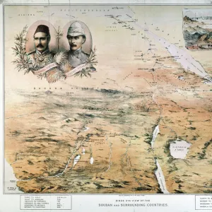
Telegraph map of Upper Egypt 1882 (litho)
2973889 Telegraph map of Upper Egypt 1882 (litho) by English School, (19th century); National Army Museum, London; (add.info.: Telegraph map of Upper Egypt 1882, compiled by the Intelligence Branch, War Office; scale 1:4 000 000; one of five maps, probably belonging to Capt George Frederick Wilson, Royal Engineers, Superintendent of Works on the Sudan Military Railway during the 1st Sudan War, 1884-1885.); eNational Army Museum; English, out of copyright
Media ID 22441512
© National Army Museum / Bridgeman Images
Cairo Intelligence Officer Nile Red Sea Signalling
FEATURES IN THESE COLLECTIONS
> Arts
> Artists
> Related Images
> Europe
> United Kingdom
> England
> London
> Museums
> National Army Museum
> Europe
> United Kingdom
> England
> London
> Royalty
> Europe
> United Kingdom
> England
> London
> Transport
> Railway
> Fine Art Finder
> Artists
> English School
> Fine Art Finder
> Artists
> Sudanese School
> Fine Art Finder
> Maps (celestial & Terrestrial)
EDITORS COMMENTS
This lithograph, titled "Telegraph map of Upper Egypt 1882" offers a fascinating glimpse into the intricate world of intelligence and engineering during the late 19th century. The print showcases a meticulously detailed map compiled by the Intelligence Branch of the War Office, focusing on Upper Egypt. The scale of this map is an impressive 1:4,000,000, allowing viewers to explore the topography and significant landmarks with great precision. It is believed that this particular map belonged to Captain George Frederick Wilson, a skilled Royal Engineer who served as Superintendent of Works on the Sudan Military Railway during the First Sudan War in 1884-1885. As we examine this historical artifact further, it becomes apparent that its purpose extended beyond mere cartography. The inclusion of telegraph lines highlights their crucial role in communication and signaling during military operations. Moreover, references to railways suggest advancements in transportation infrastructure within Africa at that time. The vibrant colors and delicate engravings bring life to this piece while simultaneously evoking a sense of nostalgia for an era long gone. This lithograph serves as both an artistic representation and a valuable historical document capturing key aspects of African geography and British military involvement in Egypt. Displayed at London's National Army Museum today, this image provides us with invaluable insights into past intelligence practices while reminding us how far we have come in terms of technological advancements since then.
MADE IN THE USA
Safe Shipping with 30 Day Money Back Guarantee
FREE PERSONALISATION*
We are proud to offer a range of customisation features including Personalised Captions, Color Filters and Picture Zoom Tools
SECURE PAYMENTS
We happily accept a wide range of payment options so you can pay for the things you need in the way that is most convenient for you
* Options may vary by product and licensing agreement. Zoomed Pictures can be adjusted in the Cart.