Home > Aerial Photography > England
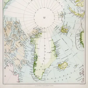
The coasts of France, England and Ireland, from Collection of Dutch Marine Maps

![]()
Wall Art and Photo Gifts from Fine Art Finder
The coasts of France, England and Ireland, from Collection of Dutch Marine Maps
BIF271728 The coasts of France, England and Ireland, from Collection of Dutch Marine Maps (engraving) by Dutch School, (17th century); Bibliotheque de l Institut de France, Paris, France; (add.info.: Recueil de cartes marines hollandaises; ); Dutch, out of copyright
Media ID 22949858
© Bridgeman Images
Aerial View Countries Iceland Islands Latitude Longitude Nautical North Pole
FEATURES IN THESE COLLECTIONS
> Aerial Photography
> England
> Aerial Photography
> Iceland
> Aerial Photography
> Ireland
> Aerial Photography
> Related Images
> Arts
> Artists
> I
> Irish School Irish School
> Europe
> France
> Paris
> Maps
> Europe
> Iceland
> Aerial Views
> Fine Art Finder
> Artists
> Dutch School
> Fine Art Finder
> Artists
> Jan van Beers
> Fine Art Finder
> Maps (celestial & Terrestrial)
EDITORS COMMENTS
This print showcases the coasts of France, England, and Ireland as seen from a collection of Dutch marine maps dating back to the 17th century. The intricate engraving depicts an aerial view of these coastal regions, highlighting their geographical features with remarkable detail. The image transports us back in time to an era of exploration and discovery, where brave sailors embarked on perilous journeys across vast oceans. The ships depicted in the print evoke a sense of adventure and curiosity that characterized this period in history. From the North Pole down to the British Isles, this artwork captures not only the beauty but also the importance of these coastlines for navigation purposes. Longitude and latitude lines are meticulously marked, emphasizing how crucial accurate cartography was for seafarers during this time. As we gaze upon this historical artifact, we cannot help but marvel at its significance. It serves as a reminder of our human desire to explore new territories and expand our knowledge beyond familiar shores. This print is truly a testament to both artistic skill and scientific precision. Now housed within the prestigious Bibliotheque de l'Institut de France in Paris, it stands as a timeless representation of maritime history. Its presence allows us to appreciate how far we have come while honoring those who paved the way for modern nautical exploration.
MADE IN THE USA
Safe Shipping with 30 Day Money Back Guarantee
FREE PERSONALISATION*
We are proud to offer a range of customisation features including Personalised Captions, Color Filters and Picture Zoom Tools
SECURE PAYMENTS
We happily accept a wide range of payment options so you can pay for the things you need in the way that is most convenient for you
* Options may vary by product and licensing agreement. Zoomed Pictures can be adjusted in the Cart.