Home > Europe > Norway > Maps
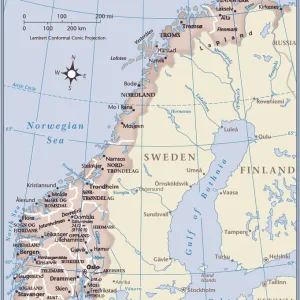
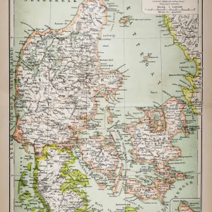
Map of the Nordic countries, kingdoms of Denmark, Sweden and Norway (etching, 1730)
")
![]()
Wall Art and Photo Gifts from Fine Art Finder
Map of the Nordic countries, kingdoms of Denmark, Sweden and Norway (etching, 1730)
LRI4706363 Map of the Nordic countries, kingdoms of Denmark, Sweden and Norway (etching, 1730) by Delisle, Guillaume (1675-1726); Private Collection; (add.info.: Map of the Nordic countries, kingdoms of Denmark, Sweden and Norway - Strong water extracted from the " New Atlas containing all parts of the world" 1730 by Guillaume de L Isle (1675-1726)); Luisa Ricciarini; French, out of copyright
Media ID 22467696
© Luisa Ricciarini / Bridgeman Images
Atlas Book Danish Danish Women Denmark Geographical Map Nordic Countries Norvege Norwegian Suede Swedish
FEATURES IN THESE COLLECTIONS
> Arts
> Artists
> Related Images
> Fine Art Finder
> Artists
> Guillaume Delisle
> Fine Art Finder
> Artists
> Italian School
> Maps and Charts
> World
EDITORS COMMENTS
This print showcases a remarkable etching from 1730, depicting the map of the Nordic countries and kingdoms of Denmark, Sweden, and Norway. Created by renowned cartographer Guillaume de L'Isle, this piece is an exquisite example of his mastery in geographical mapping. The intricacy and attention to detail in this etching are truly awe-inspiring. Every line and contour on the map has been meticulously engraved, offering a comprehensive view of these northern European lands. It is fascinating to observe how the borders have evolved over time and gain insight into the political landscape during that era. Originally extracted from "The New Atlas Containing All Parts of the World" this particular edition was printed using strong water extraction techniques. The result is a stunning visual representation that captures both the beauty and complexity of these Nordic territories. Luisa Ricciarini's expertly captured photograph allows us to appreciate every nuance within this historical artifact. From Danish women adorned in traditional attire to Swedish landscapes stretching across vast expanses, there is much to explore within this image. As we delve into its details, we are transported back to a time when maps were not only navigational tools but also works of art. This masterpiece serves as a testament to human curiosity about our world's geography while showcasing artistic talent that transcends time.
MADE IN THE USA
Safe Shipping with 30 Day Money Back Guarantee
FREE PERSONALISATION*
We are proud to offer a range of customisation features including Personalised Captions, Color Filters and Picture Zoom Tools
SECURE PAYMENTS
We happily accept a wide range of payment options so you can pay for the things you need in the way that is most convenient for you
* Options may vary by product and licensing agreement. Zoomed Pictures can be adjusted in the Cart.