Home > Europe > Italy > Tuscany > Florence
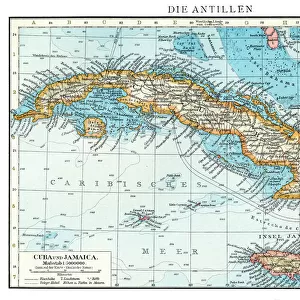
The West Indies: Florida, Honduras, Cuba, Peru and the Caribbean

![]()
Wall Art and Photo Gifts from Fine Art Finder
The West Indies: Florida, Honduras, Cuba, Peru and the Caribbean
LRI4648304 The West Indies: Florida, Honduras, Cuba, Peru and the Caribbean (Detail of the Portulan de Castellini, 17th century) by Unknown Artist, (17th century); Istituto e Museo di Storia della Scienza, Florence, Italy; (add.info.: The West Indies: Florida, Honduras, Cuba, Peru and the Caribbean - Detail of the Portulan de Castellini, 17th century Museo Storia della Scienza, Florence, Italy); Luisa Ricciarini; out of copyright
Media ID 23015674
© Luisa Ricciarini / Bridgeman Images
Central America Geographical Map Pink Winds
FEATURES IN THESE COLLECTIONS
> Arts
> Artists
> Related Images
> Europe
> Italy
> Related Images
> Europe
> Italy
> Tuscany
> Florence
> Fine Art Finder
> Artists
> Giuliano Giamberti da Sangallo
> Fine Art Finder
> Artists
> Unknown Artist
> Maps and Charts
> Italy
> Maps and Charts
> Related Images
> North America
> Cuba
> Maps
EDITORS COMMENTS
This print showcases a remarkable piece of cartographic history, "The West Indies: Florida, Honduras, Cuba, Peru and the Caribbean". Created by an unknown artist in the 17th century, this detail from the Portulan de Castellini map is housed in the prestigious Istituto e Museo di Storia della Scienza in Florence, Italy. The intricate details of this map transport us back to a time when exploration was at its peak. It offers a glimpse into the geographical knowledge and navigational expertise of that era. The vibrant colors and delicate lines depict various regions including Florida, Honduras, Cuba, Peru, and other parts of the Caribbean. As we delve into this artwork's historical significance, it becomes evident that it holds immense value for scholars studying American geography. Its inclusion of South America and Central America further adds to its importance as a comprehensive representation of these regions during that period. Luisa Ricciarini has skillfully captured this awe-inspiring map through her lens while preserving its authenticity. This particular photograph allows us to appreciate every minute detail with clarity. With its rich hues and intricate patterns evoking curiosity about past explorations and trade routes across these lands; this print serves as both an educational tool for geography enthusiasts and a stunning piece of art for any collector's gallery.
MADE IN THE USA
Safe Shipping with 30 Day Money Back Guarantee
FREE PERSONALISATION*
We are proud to offer a range of customisation features including Personalised Captions, Color Filters and Picture Zoom Tools
SECURE PAYMENTS
We happily accept a wide range of payment options so you can pay for the things you need in the way that is most convenient for you
* Options may vary by product and licensing agreement. Zoomed Pictures can be adjusted in the Cart.