Home > Asia > Armenia > Maps
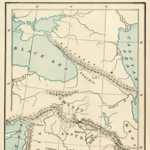
Asia Minor, Armenia, Mesopotamia, Assyria and Syria in Antiquite - Plate extracted

![]()
Wall Art and Photo Gifts from Fine Art Finder
Asia Minor, Armenia, Mesopotamia, Assyria and Syria in Antiquite - Plate extracted
XEE4152137 Asia Minor, Armenia, Mesopotamia, Assyria and Syria in Antiquite - Plate extracted from " Universal Atlas of Ancient and Modern Geography for the Use of Residential Schools" by Vuillemin - ca. 1845 by French School, (19th century); Private Collection; (add.info.: Asia Minor, Armenia, Mesopotamia, Assyria and Syria in Antiquite - Plate extracted from " Universal Atlas of Ancient and Modern Geography for the Use of Residential Schools" by Vuillemin - ca. 1845); Stefano Bianchetti; French, out of copyright
Media ID 22297410
© Stefano Bianchetti / Bridgeman Images
Armenia Armenian Assyria Atlas Book Geographical Map Mesopotamia Syria
FEATURES IN THESE COLLECTIONS
> Arts
> Artists
> Related Images
> Fine Art Finder
> Artists
> French School
> Maps and Charts
> Early Maps
EDITORS COMMENTS
This print showcases a historical map titled "Asia Minor, Armenia, Mesopotamia, Assyria and Syria in Antiquite". Extracted from the renowned "Universal Atlas of Ancient and Modern Geography for the Use of Residential Schools" by Vuillemin, this plate offers a glimpse into the rich heritage of these ancient lands. Created by the French School in the 19th century, this piece now resides in a private collection. The intricate details on this geographical map provide an invaluable resource for understanding the region's past. From Asia Minor to Armenia, Mesopotamia to Assyria and Syria, each area is meticulously depicted with precision and accuracy. This visual representation allows us to visualize how these territories were interconnected during antiquity. Dating back to approximately 1845, this engraving serves as a testament to both historical significance and artistic craftsmanship. The delicate lines and expert shading bring life to every contour of landmasses and water bodies portrayed. As we explore this mesmerizing artwork by Stefano Bianchetti through Fine Art Finder's lens, we are transported back in time—immersing ourselves in the wonders of ancient civilizations that once thrived across these lands. It reminds us of our shared human history and encourages us to delve deeper into their stories.
MADE IN THE USA
Safe Shipping with 30 Day Money Back Guarantee
FREE PERSONALISATION*
We are proud to offer a range of customisation features including Personalised Captions, Color Filters and Picture Zoom Tools
SECURE PAYMENTS
We happily accept a wide range of payment options so you can pay for the things you need in the way that is most convenient for you
* Options may vary by product and licensing agreement. Zoomed Pictures can be adjusted in the Cart.