Home > Arts > Artists > H > Hubert Hubert
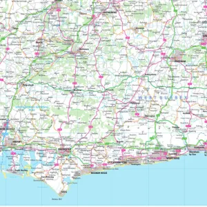
Chart of the English coast, Isle of Wight and Portsmouth harbour, 1693 (coloured engraving)
")
![]()
Wall Art and Photo Gifts from Fine Art Finder
Chart of the English coast, Isle of Wight and Portsmouth harbour, 1693 (coloured engraving)
7339372 Chart of the English coast, Isle of Wight and Portsmouth harbour, 1693 (coloured engraving) by Jaillot, Alexis-Hubert (1632-1712); 64x97 cm; National Maritime Museum, London, UK; (add.info.: Creator: [Alexis Hubert Jaillot]; [Jaillot]
Single sheet. Hand col. engr. Scale: a[1:95, 000 (bar)]. Cartographic Note: Borders graduated for lat & long, Ferro meridian. Rhumb lines. Sandbanks and soundings shown. Scales in French & English leagues, German leagues, Spanish leagues, and toises. Additional Places: Solent. Inscribed 'Carte particuliere des costes meridionales d'Angleterre qui comprend l'Isle de Wicht, et le havre de Porsmouth, avec les autres isles, bancs, et costes qui sont entre le havre de Chichester et ce luy de la Pole. Levee et gravee par ordre du Roy a Paris 1693.'); © National Maritime Museum, Greenwich, London
Media ID 38176996
© © National Maritime Museum, Greenwich, London / Bridgeman Images
Boat Dock Coast Line Hampshire Harbor Area Harbour Area Harbours Isle Of Wight Port Area Portsmouth
FEATURES IN THESE COLLECTIONS
> Arts
> Artists
> H
> Hubert Hubert
> Europe
> France
> Heritage Sites
> Le Havre, the City Rebuilt by Auguste
> Europe
> France
> Paris
> Maps
> Europe
> Republic of Ireland
> Maps
> Europe
> United Kingdom
> England
> Chichester
> Europe
> United Kingdom
> England
> Hampshire
> Portsmouth
> Fine Art Finder
> Artists
> Alexis-Hubert Jaillot
EDITORS COMMENTS
This stunning colored engraving from 1693 showcases a detailed chart of the English coast, Isle of Wight, and Portsmouth harbor. Created by Alexis-Hubert Jaillot, this piece is not only a beautiful work of art but also a valuable historical document. The intricate borders are graduated for latitude and longitude, with rhumb lines adding to the navigational accuracy.
The map includes sandbanks and soundings, as well as scales in French, English, German, and Spanish leagues. It provides a comprehensive view of the Solent area and other islands, banks, and coasts between Chichester Harbor and Pole Harbor. Inscribed with detailed information about its creation under royal orders in Paris in 1693.
This piece captures the essence of maritime cartography in the 17th century with its precise details and artistic flair. It offers viewers a glimpse into the past when navigation relied on maps like these for safe passage along coastal waters.
Displayed at the National Maritime Museum in London, this print is not just an artwork but also a historical treasure that sheds light on England's coastal geography during that time period. A must-have for any history buff or lover of nautical themes.
MADE IN THE USA
Safe Shipping with 30 Day Money Back Guarantee
FREE PERSONALISATION*
We are proud to offer a range of customisation features including Personalised Captions, Color Filters and Picture Zoom Tools
SECURE PAYMENTS
We happily accept a wide range of payment options so you can pay for the things you need in the way that is most convenient for you
* Options may vary by product and licensing agreement. Zoomed Pictures can be adjusted in the Cart.