Home > Arts > Artists > A > Battista Agnese
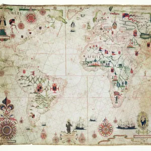
The New World, from an Atlas of the World in 33 Maps, Venice, 1st September 1553

![]()
Wall Art and Photo Gifts from Fine Art Finder
The New World, from an Atlas of the World in 33 Maps, Venice, 1st September 1553
XOT330959 The New World, from an Atlas of the World in 33 Maps, Venice, 1st September 1553 (ink on vellum) (see also 330961) by Agnese, Battista (1514-64); 29x49 cm; Museo Correr, Venice, Italy; Italian, out of copyright
Media ID 12852680
© www.bridgemanart.com
Atlantic Ocean Cartography Compass Mapping Nautical Chart Portolan
FEATURES IN THESE COLLECTIONS
> Africa
> Related Images
> Arts
> Artists
> A
> Battista Agnese
> Europe
> Italy
> Veneto
> Venice
> Fine Art Finder
> Artists
> Battista Agnese
> Fine Art Finder
> Maps (celestial & Terrestrial)
> Maps and Charts
> Italy
> Maps and Charts
> World
EDITORS COMMENTS
This print showcases "The New World" from an Atlas of the World in 33 Maps, created by Battista Agnese on September 1st, 1553. The ink on vellum artwork measures 29x49 cm and is currently housed at the Museo Correr in Venice, Italy. Agnese's masterpiece takes us back to a time when cartography was still in its infancy. This particular map portrays a fascinating blend of nautical charting and artistic flair. It depicts Africa, Europe, and the vast Atlantic Ocean with meticulous detail while highlighting the discovery of America. As we gaze upon this ancient treasure, our eyes are drawn to the intricate compass rose that sits proudly at its center. Its delicate lines symbolize not only direction but also exploration and curiosity about what lies beyond known horizons. "The New World" map serves as a testament to humanity's insatiable thirst for knowledge and adventure during the Renaissance era. It transports us back to a time when brave explorers set sail into uncharted waters, driven by their desire to unravel mysteries and expand their understanding of the world. Through this remarkable piece of artistry, we can almost hear whispers from centuries past – tales of daring voyages across treacherous seas and encounters with indigenous cultures previously unknown to Europeans. In preserving this historical artifact through photography, Fine Art Finder allows us all to marvel at Agnese's skillful craftsmanship while appreciating how far we have come in our own mapping endeavors
MADE IN THE USA
Safe Shipping with 30 Day Money Back Guarantee
FREE PERSONALISATION*
We are proud to offer a range of customisation features including Personalised Captions, Color Filters and Picture Zoom Tools
SECURE PAYMENTS
We happily accept a wide range of payment options so you can pay for the things you need in the way that is most convenient for you
* Options may vary by product and licensing agreement. Zoomed Pictures can be adjusted in the Cart.