Home > Europe > United Kingdom > Scotland > Moray > Keith
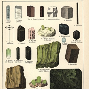
Illustrations of Chartography (coloured engraving)
")
![]()
Wall Art and Photo Gifts from Fine Art Finder
Illustrations of Chartography (coloured engraving)
7159908 Illustrations of Chartography (coloured engraving) by English School, (19th century); Private Collection; (add.info.: Illustrations of Chartography. Illustration for A School Atlas of Physical Geography by Alex Keith Johnston (William Blackwood, 1852).); © Look and Learn
Media ID 24681394
© Look and Learn / Bridgeman Images
City Map City Plan General Map Street Plan
FEATURES IN THESE COLLECTIONS
> Arts
> Artists
> K
> William Keith
> Europe
> United Kingdom
> Scotland
> Moray
> Keith
> Fine Art Finder
> Artists
> American Photographer (after)
> Fine Art Finder
> Artists
> English School
> Maps and Charts
> Early Maps
> Maps and Charts
> Related Images
EDITORS COMMENTS
This print showcases a coloured engraving titled "Illustrations of Chartography" by an English School in the 19th century. The artwork is part of a private collection and was originally created as an illustration for A School Atlas of Physical Geography by Alex Keith Johnston, published in 1852. The image transports us back to the early 19th century, immersing us in its rich history and providing a glimpse into the world of cartography during that time. The intricate details and vibrant colours bring life to various maps depicted within the engraving. From general maps to city plans and street layouts, this piece offers a comprehensive overview of geographical representations from that era. It serves as both an educational tool and a testament to the artistry involved in mapmaking during this period. As we explore this remarkable artwork, we are reminded of how far cartography has come since then. Yet, it also sparks curiosity about how these historical maps shaped our understanding of geography at that time. With Bridgeman Images capturing this stunning photograph from Fine Art Finder's collection, we can now appreciate and admire this exquisite piece without limitations or commercial use restrictions.
MADE IN THE USA
Safe Shipping with 30 Day Money Back Guarantee
FREE PERSONALISATION*
We are proud to offer a range of customisation features including Personalised Captions, Color Filters and Picture Zoom Tools
SECURE PAYMENTS
We happily accept a wide range of payment options so you can pay for the things you need in the way that is most convenient for you
* Options may vary by product and licensing agreement. Zoomed Pictures can be adjusted in the Cart.