Home > Arts > Landscape paintings > Waterfall and river artworks > River artworks
EXPL2A-00124

![]()
Wall Art and Photo Gifts from North Wind
EXPL2A-00124
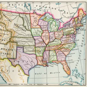
Fort Rozalie des Natchez on the Mississippi River 1700s - North is to the right.
Hand-colored woodcut of a map published in 1770. Fleuve Saint Louis was the French name for the Mississippi River
North Wind Picture Archives brings history to life with stock images and hand-colored illustrations
Media ID 5880465
© North Wind Picture Archives
1770 18th Century Boat Colonial Colony Fort French Frontier Louisiana Territory Mississippi River New France Outpost Pioneer Road Settlement Settler Town Village Natchez River Mississippi Rosalie
FEATURES IN THESE COLLECTIONS
> Arts
> Landscape paintings
> Waterfall and river artworks
> River artworks
> North America
> Related Images
> North Wind Picture Archives
> Exploration
EDITORS COMMENTS
This hand-colored woodcut print takes us back to the 1700s, offering a glimpse into the rich history of North America. The focal point of the image is Fort Rozalie des Natchez, an impressive outpost situated on the banks of the mighty Mississippi River. With its strategic location and commanding presence, this fort served as a vital frontier settlement during colonial times. The artist's attention to detail is evident in every stroke, beautifully capturing the essence of this historic village. A meandering road leads us through a quaint American town that thrived amidst untamed wilderness. The pioneer spirit comes alive as we envision settlers navigating their way along this path towards new opportunities. Boats gracefully glide along the river's currents, symbolizing both transportation and trade routes that shaped early American history. This map provides valuable insight into New France and Louisiana Territory during a time when French influence was prominent in these regions. As we explore this vintage illustration, it becomes clear that it holds more than just aesthetic value; it serves as a visual portal connecting us with our past. It reminds us of the brave men and women who ventured into unknown territories to establish colonies and build forts like Fort Rozalie des Natchez. With North Wind Picture Archives' dedication to preserving historical artistry, we can appreciate how far our nation has come while honoring those who laid its foundations centuries ago.
MADE IN THE USA
Safe Shipping with 30 Day Money Back Guarantee
FREE PERSONALISATION*
We are proud to offer a range of customisation features including Personalised Captions, Color Filters and Picture Zoom Tools
SECURE PAYMENTS
We happily accept a wide range of payment options so you can pay for the things you need in the way that is most convenient for you
* Options may vary by product and licensing agreement. Zoomed Pictures can be adjusted in the Cart.