Home > Europe > France > Canton > Meurthe
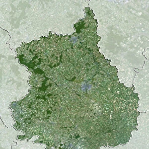
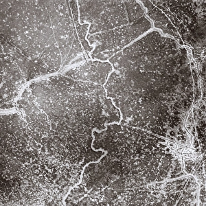
Departement of Meurthe-et-Moselle, France, Relief Map

![]()
Wall Art and Photo Gifts from Universal Images Group (UIG)
Departement of Meurthe-et-Moselle, France, Relief Map
Relief map of the departement of Meurthe-et-Moselle, France. It is bordered by Luxembourg and Belgium at north. This image was compiled from data acquired by LANDSAT 5 & 7 satellites combined with elevation data
Universal Images Group (UIG) manages distribution for many leading specialist agencies worldwide
Media ID 9633967
© Planet Observer
Geographical Border Lorraine Relief Map Meurthe Et Moselle Satellite View
FEATURES IN THESE COLLECTIONS
> Aerial Photography
> Belgium
> Aerial Photography
> Luxembourg
> Europe
> France
> Canton
> Meurthe
> Europe
> France
> Canton
> Moselle
> Europe
> Luxembourg
> Maps
> Universal Images Group (UIG)
> Universal Images Group
> Satellite and Aerial
> Planet Observer 5
MADE IN THE USA
Safe Shipping with 30 Day Money Back Guarantee
FREE PERSONALISATION*
We are proud to offer a range of customisation features including Personalised Captions, Color Filters and Picture Zoom Tools
SECURE PAYMENTS
We happily accept a wide range of payment options so you can pay for the things you need in the way that is most convenient for you
* Options may vary by product and licensing agreement. Zoomed Pictures can be adjusted in the Cart.