Canvas Print > Europe > United Kingdom > Wales > Maps
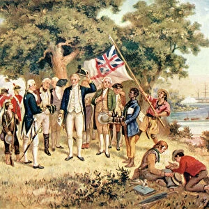
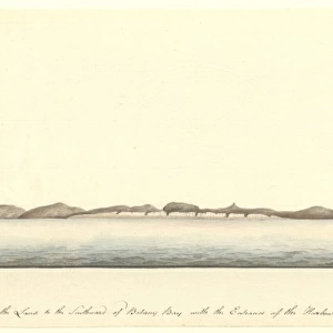
Canvas Print : Map of Botany Bay, New South Wales, Australia


![]()
Canvas Prints from Universal Images Group (UIG)
Map of Botany Bay, New South Wales, Australia
Cartography, 18th century. Map of Botany Bay, New South Wales, Australia
Universal Images Group (UIG) manages distribution for many leading specialist agencies worldwide
Media ID 9502003
© DEA PICTURE LIBRARY
18th Century Australia Coastline New South Wales Western Script Botany Bay
20"x16" (51x41cm) Canvas Print
Discover the rich history of Australia with our exquisite Canvas Prints from Media Storehouse. This stunning Map of Botany Bay, New South Wales, Australia, sourced from Universal Images Group, transports you back in time to the 18th century. The intricate cartography of this vintage map showcases the earliest known European exploration of the iconic Australian landmark. Add this beautiful piece to your home decor to inspire wanderlust and ignite conversations. Order your Canvas Print today and bring a piece of history into your living space.
Delivered stretched and ready to hang our premium quality canvas prints are made from a polyester/cotton blend canvas and stretched over a 1.25" (32mm) kiln dried knot free wood stretcher bar. Packaged in a plastic bag and secured to a cardboard insert for safe transit.
Canvas Prints add colour, depth and texture to any space. Professionally Stretched Canvas over a hidden Wooden Box Frame and Ready to Hang
Estimated Product Size is 50.8cm x 40.6cm (20" x 16")
These are individually made so all sizes are approximate
Artwork printed orientated as per the preview above, with landscape (horizontal) orientation to match the source image.
FEATURES IN THESE COLLECTIONS
> Europe
> United Kingdom
> Wales
> Maps
> Europe
> United Kingdom
> Wales
> Paintings
> Europe
> United Kingdom
> Wales
> Related Images
> Maps and Charts
> Related Images
> Maps and Charts
> Wales
> Oceania
> Australia
> Related Images
> Universal Images Group (UIG)
> Art
> Painting, Sculpture & Prints
> Cartography
EDITORS COMMENTS
This 18th-century map of Botany Bay, New South Wales, Australia takes us on a journey back in time to the early days of exploration and cartography. With its intricate details and Western script annotations, this print offers a glimpse into the rich history and topography of this iconic Australian location. The map showcases the stunning coastline of Botany Bay, stretching out horizontally across the print. The artist's skillful illustration and painting techniques bring to life the rugged beauty of this natural harbor. From its jagged cliffs to its sandy shores, every contour is meticulously depicted, offering a sense of awe-inspiring realism. Botany Bay holds immense historical significance as it was here that Captain James Cook first landed in 1770 during his voyage to chart uncharted territories. This map serves as a testament to Cook's pioneering spirit and provides valuable insights into his discoveries. As we gaze upon this remarkable piece of cartography, we are transported back in time when explorers braved unknown waters in search of new lands. It reminds us of the vastness and diversity that Australia has always offered - an untamed frontier waiting to be explored. This print from Universal Images Group (UIG) allows us to appreciate not only the artistry behind old-world maps but also their invaluable role in documenting our planet's history. Whether you're an avid historian or simply fascinated by geography, this Map of Botany Bay is sure to captivate your imagination with its timeless charm.
MADE IN THE USA
Safe Shipping with 30 Day Money Back Guarantee
FREE PERSONALISATION*
We are proud to offer a range of customisation features including Personalised Captions, Color Filters and Picture Zoom Tools
SECURE PAYMENTS
We happily accept a wide range of payment options so you can pay for the things you need in the way that is most convenient for you
* Options may vary by product and licensing agreement. Zoomed Pictures can be adjusted in the Cart.