Canvas Print > Maps and Charts > Related Images
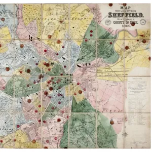
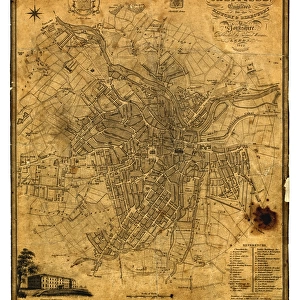
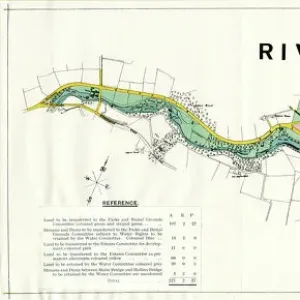
Canvas Print : Plan of Sheffield, 1838


![]()
Canvas Prints From Sheffield City Archives
Plan of Sheffield, 1838
Original at Sheffield Local Studies Library
Sheffield City Archives and Local Studies Library has an unrivalled collection of images of Sheffield, England
Media ID 14046893
© Sheffield City Council
20"x16" (51x41cm) Canvas Print
Introducing the Media Storehouse Canvas Print of "Plan of Sheffield, 1838" - a captivating piece of local history brought to life in vibrant detail. This exquisite print showcases an original map of Sheffield as it appeared over 180 years ago, preserved from the archives of Sheffield City Archives. Each print is meticulously reproduced on high-quality canvas, ensuring the intricate lines and subtle colors of the original document are faithfully rendered. Bring a piece of Sheffield's rich history into your home or office and transport yourself back in time with this stunning canvas print. Authenticity meets elegance - the perfect addition to any room.
Delivered stretched and ready to hang our premium quality canvas prints are made from a polyester/cotton blend canvas and stretched over a 1.25" (32mm) kiln dried knot free wood stretcher bar. Packaged in a plastic bag and secured to a cardboard insert for safe transit.
Canvas Prints add colour, depth and texture to any space. Professionally Stretched Canvas over a hidden Wooden Box Frame and Ready to Hang
Estimated Product Size is 50.8cm x 40.6cm (20" x 16")
These are individually made so all sizes are approximate
Artwork printed orientated as per the preview above, with landscape (horizontal) orientation to match the source image.
EDITORS COMMENTS
This print showcases the remarkable "Plan of Sheffield, 1838" an invaluable historical artifact preserved at the Sheffield Local Studies Library. The intricate map offers a fascinating glimpse into the city's past, capturing its urban landscape during a pivotal era of industrialization and growth. With meticulous detail, this plan reveals the layout and development of Sheffield in the mid-19th century. Every street, square, and landmark is intricately depicted, allowing us to trace the evolution of this vibrant city over time. From bustling marketplaces to sprawling residential areas, each element on this map tells a story of Sheffield's rich history. The craftsmanship evident in this print is truly awe-inspiring; it serves as a testament to both the cartographers' skill and their dedication to accurately documenting every aspect of Sheffield's geography. By examining this piece closely, one can discern how industry played a significant role in shaping the cityscape during that period. As we gaze upon this photograph today, we cannot help but appreciate its significance as an essential resource for researchers and historians alike. It provides valuable insights into urban planning strategies employed centuries ago while also serving as a reminder of our collective heritage. Thanks to institutions like the Sheffield City Archives who diligently preserve such treasures from our pasts with utmost care and dedication; these prints continue to enlighten us about our roots and inspire future generations with their timeless beauty.
MADE IN THE USA
Safe Shipping with 30 Day Money Back Guarantee
FREE PERSONALISATION*
We are proud to offer a range of customisation features including Personalised Captions, Color Filters and Picture Zoom Tools
SECURE PAYMENTS
We happily accept a wide range of payment options so you can pay for the things you need in the way that is most convenient for you
* Options may vary by product and licensing agreement. Zoomed Pictures can be adjusted in the Basket.