Canvas Print > Maps and Charts > Related Images
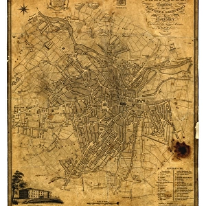
Canvas Print : Map of Sheffield


![]()
Canvas Prints From Sheffield City Archives
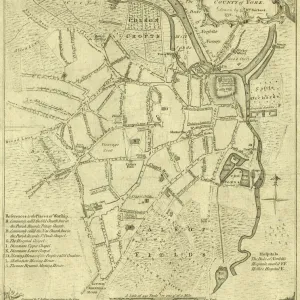
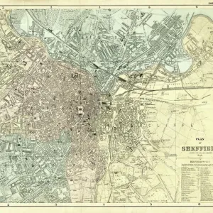
Map of Sheffield
Undated but shows the old barracks so between 1792 and 1854.Scale 2 inches : 1 mile.Local Studies ref. S38S
Sheffield City Archives and Local Studies Library has an unrivalled collection of images of Sheffield, England
Media ID 14049006
© Sheffield City Council
20"x16" (51x41cm) Canvas Print
"Discover the rich history of Sheffield with our exquisite Canvas Print of the 'Map of Sheffield' from the Sheffield City Archives. This vintage map, undated but depicting the old barracks, offers a captivating glimpse into the past. With a scale of 2 inches : 1 mile, this detailed and intricately designed map is a must-have for local history enthusiasts and those with a connection to Sheffield. Bring the charm of the past into your home or office with our high-quality Canvas Print, expertly printed on heavy duty canvas for a vibrant and long-lasting image. Order yours today and step back in time."
Delivered stretched and ready to hang our premium quality canvas prints are made from a polyester/cotton blend canvas and stretched over a 1.25" (32mm) kiln dried knot free wood stretcher bar. Packaged in a plastic bag and secured to a cardboard insert for safe transit.
Canvas Prints add colour, depth and texture to any space. Professionally Stretched Canvas over a hidden Wooden Box Frame and Ready to Hang
Estimated Product Size is 40.6cm x 50.8cm (16" x 20")
These are individually made so all sizes are approximate
Artwork printed orientated as per the preview above, with portrait (vertical) orientation to match the source image.
FEATURES IN THESE COLLECTIONS
> Maps and Charts
> Related Images
> Sheffield City Archives
> Maps and Plans
Unveiling the Untold Stories - A Glimpse into Sheffield's Historic Past
EDITORS COMMENTS
. This photo print, sourced from the Sheffield City Archives, offers an intriguing window into the rich history of this vibrant city. The undated map showcases a remarkable depiction of Sheffield during a transformative era, between 1792 and 1854. With meticulous detail and precision, it reveals an urban landscape that has long since evolved but still holds remnants of its bygone days. The focal point of this extraordinary map lies in its portrayal of the old barracks—a significant landmark that once played a pivotal role in shaping Sheffield's identity. As we delve deeper into this historical treasure trove, we are transported back to a time when bustling streets were lined with horse-drawn carriages and thriving industries fueled the city's growth. With a scale ratio of 2 inches to 1 mile, every inch on this map unravels untold stories waiting to be discovered. It beckons us to explore forgotten alleyways and hidden corners where tales from yesteryears reside. This invaluable resource serves as both a testament to our shared heritage and an invitation for future generations to uncover their roots. As we gaze upon this mesmerizing piece preserved within the Local Studies collection (ref. S38S), let us not forget its significance extends beyond mere commercial use or geographical reference. Instead, let it serve as a reminder that behind each street name lies narratives woven by countless lives lived throughout centuries—an ode to resilience, progress
MADE IN THE USA
Safe Shipping with 30 Day Money Back Guarantee
FREE PERSONALISATION*
We are proud to offer a range of customisation features including Personalised Captions, Color Filters and Picture Zoom Tools
SECURE PAYMENTS
We happily accept a wide range of payment options so you can pay for the things you need in the way that is most convenient for you
* Options may vary by product and licensing agreement. Zoomed Pictures can be adjusted in the Basket.