
Canvas Print > Maps and Charts > Related Images
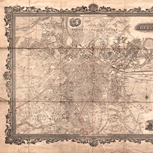
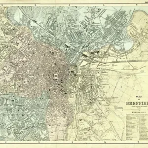
Canvas Print : Map of twenty miles around Sheffield, engraved for the directory of 1852


![]()
Canvas Prints from Sheffield City Archives
Map of twenty miles around Sheffield, engraved for the directory of 1852
Scale 3 miles : 1 inch.Size 41 x 34 cm.Original at Local Studies A11S
Sheffield City Archives and Local Studies Library has an unrivalled collection of images of Sheffield, England
Media ID 14047922
© Sheffield City Council
20"x16" (51x41cm) Canvas Print
"Discover the history of Sheffield with our stunning Canvas Print of a rare 1852 map. This intricately detailed engraving, sourced from the Sheffield City Archives, offers a captivating glimpse into the past. The Map of Twenty Miles Around Sheffield, originally featured in the city directory, showcases the local area with a scale of three miles to one inch. Each Canvas Print is meticulously crafted, bringing the historical charm of this unique piece to your home or office. Add a touch of timeless character to your space with Media Storehouse's Canvas Print of the Sheffield Map from 1852."
Delivered stretched and ready to hang our premium quality canvas prints are made from a polyester/cotton blend canvas and stretched over a 1.25" (32mm) kiln dried knot free wood stretcher bar. Packaged in a plastic bag and secured to a cardboard insert for safe transit.
Canvas Prints add colour, depth and texture to any space. Professionally Stretched Canvas over a hidden Wooden Box Frame and Ready to Hang
Estimated Product Size is 40.6cm x 50.8cm (16" x 20")
These are individually made so all sizes are approximate
Artwork printed orientated as per the preview above, with portrait (vertical) orientation to match the source image.
FEATURES IN THESE COLLECTIONS
> Maps and Charts
> Related Images
> Sheffield City Archives
> Maps and Plans
EDITORS COMMENTS
This print showcases a historical gem, the "Map of twenty miles around Sheffield" engraved specifically for the directory of 1852. With its impressive scale of 3 miles to 1 inch, this map offers an intricate and detailed representation of the region's landscape during that era. Measuring at a substantial size of 41 x 34 cm, it is truly a testament to the meticulous craftsmanship employed in its creation. Preserved within Sheffield City Archives' Local Studies collection (A11S), this remarkable piece provides us with a fascinating glimpse into the past. It allows us to explore and understand how Sheffield and its surrounding areas were structured over one and a half centuries ago. The map not only serves as an invaluable resource for historians but also captivates those with an interest in cartography or local geography. Its fine engravings depict various landmarks, roads, rivers, and settlements that once shaped this vibrant region. As we admire this print from Sheffield City Archives today, let us appreciate the dedication put forth by those who meticulously crafted such maps in earlier times. While we cannot overlook their commercial value back then – aiding businesses in navigating these lands – let us focus on appreciating it as an artifact representing our rich history rather than considering any potential commercial use it may have had.
MADE IN THE USA
Safe Shipping with 30 Day Money Back Guarantee
FREE PERSONALISATION*
We are proud to offer a range of customisation features including Personalised Captions, Color Filters and Picture Zoom Tools
SECURE PAYMENTS
We happily accept a wide range of payment options so you can pay for the things you need in the way that is most convenient for you
* Options may vary by product and licensing agreement. Zoomed Pictures can be adjusted in the Cart.


![[South] Part of the West Riding of Yorkshire, 1796](/sq/716/south-west-riding-yorkshire-1796-14047414.jpg.webp)