Canvas Print > North America > Canada > Maps
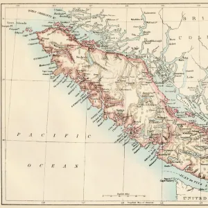
Canvas Print : Quebec, 1870s


![]()
Canvas Prints from North Wind
Quebec, 1870s
Map of Quebec province, Canada, 1870s.
Printed color lithograph
North Wind Picture Archives brings history to life with stock images and hand-colored illustrations
Media ID 5879745
© North Wind Picture Archives
1870s Canada Canadian French Canada French Canadian Gaspee Quebec
30"x20" (76x51cm) Canvas Print
Step back in time with our stunning Canvas Print of "Quebec, 1870s" by North Wind Picture Archives. This captivating piece of historical art transport you to the heart of Quebec province, Canada during the 1870s. The intricate details of the Map of Quebec, printed in vibrant colors through color lithography, bring the past to life. Hang this beautiful canvas print in your home or office to add an air of sophistication and historical charm. A perfect addition to any decor, this canvas print is sure to be a conversation starter and a cherished piece of art for generations to come.
Delivered stretched and ready to hang our premium quality canvas prints are made from a polyester/cotton blend canvas and stretched over a 1.25" (32mm) kiln dried knot free wood stretcher bar. Packaged in a plastic bag and secured to a cardboard insert for safe transit.
Canvas Prints add colour, depth and texture to any space. Professionally Stretched Canvas over a hidden Wooden Box Frame and Ready to Hang
Estimated Product Size is 76.2cm x 50.8cm (30" x 20")
These are individually made so all sizes are approximate
Artwork printed orientated as per the preview above, with landscape (horizontal) orientation to match the source image.
FEATURES IN THESE COLLECTIONS
> Maps and Charts
> Related Images
> North America
> Canada
> Maps
> North America
> Canada
> Related Images
> North Wind Picture Archives
> Canadian history
> North Wind Picture Archives
> Maps
EDITORS COMMENTS
This vintage print takes us back to the 1870s, offering a glimpse into the rich history and heritage of Quebec province in Canada. The beautifully detailed map showcases the region's vast landscapes, towns, and rivers with intricate precision. Printed using lithograph techniques and adorned with vibrant colors, this artwork captures the essence of traditional cartography from a bygone era. The illustration transports us to a time when French Canadian culture thrived in Quebec. As we explore the map, we can imagine the bustling streets of historic cities like Montreal and Quebec City, where echoes of centuries-old architecture still stand today. The Gaspee Peninsula stands out prominently on this map as well – an area known for its natural beauty and historical significance. Beyond its aesthetic appeal, this piece serves as a valuable historical artifact that sheds light on Canada's past. It reminds us of how borders have evolved over time and offers insight into North America's changing landscape during the late 19th century. North Wind Picture Archives has expertly preserved this piece of artistry for future generations to appreciate. Whether you are an art enthusiast or a history buff, this print is sure to transport you back in time while celebrating the enduring legacy of French Canada in all its glory.
MADE IN THE USA
Safe Shipping with 30 Day Money Back Guarantee
FREE PERSONALISATION*
We are proud to offer a range of customisation features including Personalised Captions, Color Filters and Picture Zoom Tools
SECURE PAYMENTS
We happily accept a wide range of payment options so you can pay for the things you need in the way that is most convenient for you
* Options may vary by product and licensing agreement. Zoomed Pictures can be adjusted in the Cart.