Canvas Print > Arts > Landscape paintings > Waterfall and river artworks > River artworks
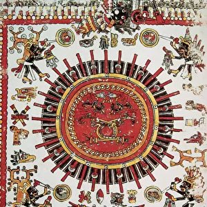
Canvas Print : World Map / Leipzig Codex


![]()
Canvas Prints from Mary Evans Picture Library
World Map / Leipzig Codex
A German map of the world, showing various cities, rivers and seas
Mary Evans Picture Library makes available wonderful images created for people to enjoy over the centuries
Media ID 608724
© Mary Evans Picture Library 2015 - https://copyrighthub.org/s0/hub1/creation/maryevans/MaryEvansPictureID/10113651
11th Cities Codex Leipzig Maps Rivers Seas
20"x16" (51x41cm) Canvas Print
Introducing the captivating "World Map / Leipzig Codex" from our Media Storehouse collection of Canvas Prints, brought to you by Mary Evans Picture Library from Mary Evans Prints Online. This exquisite piece of cartographic art showcases a detailed and intricately designed German world map from the Leipzig Codex, a 16th-century atlas. Discover the ancient depiction of continents, seas, and prominent cities, including Vienna, Constantinople, and Cairo. Elevate your home or office decor with this timeless and educational masterpiece, expertly printed on high-quality canvas for a vibrant and long-lasting display. Experience the fusion of history, art, and contemporary style with our Canvas Prints.
Delivered stretched and ready to hang our premium quality canvas prints are made from a polyester/cotton blend canvas and stretched over a 1.25" (32mm) kiln dried knot free wood stretcher bar. Packaged in a plastic bag and secured to a cardboard insert for safe transit.
Canvas Prints add colour, depth and texture to any space. Professionally Stretched Canvas over a hidden Wooden Box Frame and Ready to Hang
Estimated Product Size is 40.6cm x 50.8cm (16" x 20")
These are individually made so all sizes are approximate
Artwork printed orientated as per the preview above, with portrait (vertical) orientation to match the source image.
FEATURES IN THESE COLLECTIONS
> Arts
> Landscape paintings
> Waterfall and river artworks
> River artworks
> Europe
> Germany
> Related Images
> Maps and Charts
> Early Maps
> Maps and Charts
> Related Images
> Maps and Charts
> World
EDITORS COMMENTS
This stunning print captures a piece of history in the form of the "World Map / Leipzig Codex." Dating back to the 11th century, this German map of the world showcases various cities, rivers, and seas in intricate detail. The craftsmanship and attention to detail in this historical map are truly remarkable.
As you study this map closely, you can see how different regions were depicted by cartographers centuries ago. Each city is carefully labeled, each river intricately drawn, and each sea accurately portrayed. It's like taking a step back in time and seeing the world through the eyes of those who came before us.
The Leipzig Codex is not just a map; it's a window into our past. It tells stories of exploration, trade routes, and cultural exchanges that shaped our world as we know it today. This print allows us to appreciate the artistry and skill that went into creating such an important historical document.
Whether you're a history buff or simply appreciate beautiful works of art, this World Map from Mary Evans Picture Library is sure to captivate your imagination. Display it proudly in your home or office as a reminder of how far we've come and how much there still is to discover about our planet's rich history.
MADE IN THE USA
Safe Shipping with 30 Day Money Back Guarantee
FREE PERSONALISATION*
We are proud to offer a range of customisation features including Personalised Captions, Color Filters and Picture Zoom Tools
SECURE PAYMENTS
We happily accept a wide range of payment options so you can pay for the things you need in the way that is most convenient for you
* Options may vary by product and licensing agreement. Zoomed Pictures can be adjusted in the Cart.