Canvas Print > Oceania > Australia > Maps
Canvas Print : Maps / Australia 1860S


![]()
Canvas Prints from Mary Evans Picture Library
Maps / Australia 1860S
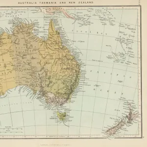
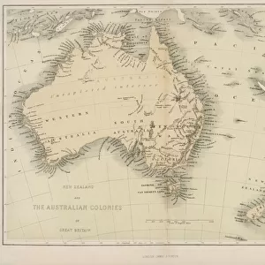
Map probably made soon after 1861
Mary Evans Picture Library makes available wonderful images created for people to enjoy over the centuries
Media ID 576482
© Mary Evans Picture Library 2015 - https://copyrighthub.org/s0/hub1/creation/maryevans/MaryEvansPictureID/10015337
20"x16" (51x41cm) Canvas Print
Discover the rich history of Australia with our stunning Canvas Prints from Media Storehouse, featuring the captivating "Maps / Australia 1860s" image by Mary Evans Picture Library from Mary Evans Prints Online. This vintage map, made soon after 1861, offers a fascinating glimpse into the exploration and development of the Australian continent during the 19th century. The intricate details and accurate depiction of the land make this a must-have addition to any home or office. Our high-quality canvas prints are meticulously crafted to bring out the vibrant colors and fine details of the map, ensuring a beautiful and long-lasting piece of art. Elevate your space with a touch of history and the timeless charm of this exquisite map of Australia.
Delivered stretched and ready to hang our premium quality canvas prints are made from a polyester/cotton blend canvas and stretched over a 1.25" (32mm) kiln dried knot free wood stretcher bar. Packaged in a plastic bag and secured to a cardboard insert for safe transit.
Canvas Prints add colour, depth and texture to any space. Professionally Stretched Canvas over a hidden Wooden Box Frame and Ready to Hang
Estimated Product Size is 50.8cm x 40.6cm (20" x 16")
These are individually made so all sizes are approximate
Artwork printed orientated as per the preview above, with landscape (horizontal) orientation to match the source image.
FEATURES IN THESE COLLECTIONS
> Maps and Charts
> Early Maps
> Maps and Charts
> Related Images
> Oceania
> Australia
> Related Images
EDITORS COMMENTS
This print of a map of Australia from the 1860s offers a fascinating glimpse into the historical geography of this vast and diverse continent. Created shortly after 1861, this meticulously detailed map provides valuable insight into the topography, settlements, and boundaries of Australia during this pivotal period in its history.
As we study this map, we can see how much has changed over the years in terms of exploration, colonization, and development. The intricate lines and labels on the map tell stories of expeditions, discoveries, and territorial disputes that have shaped Australia's landscape and identity.
From the rugged coastlines to the sprawling interior regions, every inch of land is carefully documented on this map. It serves as a reminder of the rich heritage and complex history that defines Australia as a nation.
Whether you are a history buff or simply curious about how our world has evolved over time, this vintage map is sure to spark your imagination and ignite your sense of wonder. Let yourself be transported back in time to an era when cartographers painstakingly charted unknown territories with nothing but pen and paper.
Discover Australia through new eyes with this remarkable print from Mary Evans Picture Library - a true treasure trove for anyone interested in exploring the past through maps.
MADE IN THE USA
Safe Shipping with 30 Day Money Back Guarantee
FREE PERSONALISATION*
We are proud to offer a range of customisation features including Personalised Captions, Color Filters and Picture Zoom Tools
SECURE PAYMENTS
We happily accept a wide range of payment options so you can pay for the things you need in the way that is most convenient for you
* Options may vary by product and licensing agreement. Zoomed Pictures can be adjusted in the Cart.