Canvas Print > Historic > Ancient civilizations > Roman Empire > Roman art
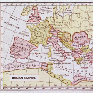
Canvas Print : Map / Roman Empire / Cup


![]()
Canvas Prints from Mary Evans Picture Library
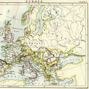
Map / Roman Empire / Cup
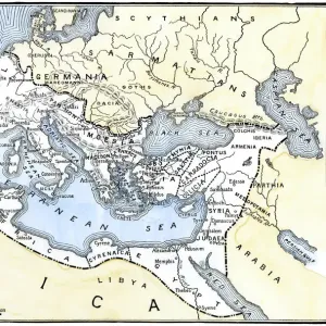
Part of the Roman Empire, showing St Pauls journeys
Mary Evans Picture Library makes available wonderful images created for people to enjoy over the centuries
Media ID 4357661
© Mary Evans Picture Library 2015 - https://copyrighthub.org/s0/hub1/creation/maryevans/MaryEvansPictureID/10114040
20"x16" (51x41cm) Canvas Print
Introducing the stunning "Map / Roman Empire / Cup" Canvas Print from the Media Storehouse collection, featuring an exquisite image from Mary Evans Prints Online. This captivating piece transports you back in time, offering a glimpse into the expansive Roman Empire. Follow in the footsteps of St. Paul as depicted in this intricately detailed map, meticulously illustrating the vast territories ruled by the Roman Empire. The Roman Empire was a powerful and influential civilization that shaped the course of history, and this print is a testament to its grandeur. The image is beautifully rendered on a high-quality canvas, ensuring vibrant colors and exceptional detail that will bring this historical masterpiece to life in your home or office. The addition of the classic Roman cup adds an authentic touch, enhancing the overall visual appeal. This Canvas Print is not only a beautiful decorative piece but also a fascinating conversation starter, perfect for history enthusiasts, educators, and anyone with an appreciation for the richness of our past. Order yours today and let the stories of the Roman Empire unfold in your space.
Delivered stretched and ready to hang our premium quality canvas prints are made from a polyester/cotton blend canvas and stretched over a 1.25" (32mm) kiln dried knot free wood stretcher bar. Packaged in a plastic bag and secured to a cardboard insert for safe transit.
Canvas Prints add colour, depth and texture to any space. Professionally Stretched Canvas over a hidden Wooden Box Frame and Ready to Hang
Estimated Product Size is 50.8cm x 40.6cm (20" x 16")
These are individually made so all sizes are approximate
Artwork printed orientated as per the preview above, with landscape (horizontal) orientation to match the source image.
FEATURES IN THESE COLLECTIONS
> Arts
> Artists
> R
> Roman Roman
> Europe
> Related Images
> Historic
> Ancient civilizations
> Roman Empire
> Roman art
> Maps and Charts
> Early Maps
> Maps and Charts
> Related Images
EDITORS COMMENTS
This print showcases a detailed map of the Roman Empire, specifically highlighting St. Paul's journeys throughout the 1st century AD. The intricate design and historical significance of this piece make it a true treasure for any history enthusiast or lover of ancient civilizations.
The map provides a fascinating glimpse into the vast expanse of the Roman Empire during its peak, offering insight into the various regions and territories that made up this powerful civilization. From Europe to parts of Africa and Asia, this map illustrates just how far-reaching and influential the Roman Empire truly was.
In addition to showcasing the expansive reach of Rome, this print also focuses on St. Paul's important travels throughout the empire. As one of Christianity's most prominent figures, St. Paul played a crucial role in spreading the teachings of Jesus Christ across different lands and cultures.
Overall, this print is not only visually stunning but also rich in historical context. It serves as a reminder of the enduring legacy of both the Roman Empire and early Christianity, making it a valuable addition to any collection focused on ancient history or religious studies.
MADE IN THE USA
Safe Shipping with 30 Day Money Back Guarantee
FREE PERSONALISATION*
We are proud to offer a range of customisation features including Personalised Captions, Color Filters and Picture Zoom Tools
SECURE PAYMENTS
We happily accept a wide range of payment options so you can pay for the things you need in the way that is most convenient for you
* Options may vary by product and licensing agreement. Zoomed Pictures can be adjusted in the Cart.