Canvas Print > Arts > Artists > R > Roman Roman
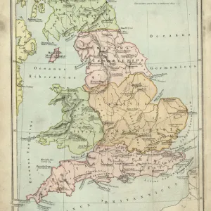
Canvas Print : Map of Pre-Roman Brits


![]()
Canvas Prints from Mary Evans Picture Library
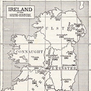
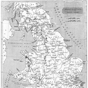
Map of Pre-Roman Brits
A map showing the distribution of tribes in pre- Roman Britain
Mary Evans Picture Library makes available wonderful images created for people to enjoy over the centuries
Media ID 4362729
© Mary Evans Picture Library 2015 - https://copyrighthub.org/s0/hub1/creation/maryevans/MaryEvansPictureID/10117076
Brits Distribution Maps Tribes
20"x16" (51x41cm) Canvas Print
"Discover the rich history of Pre-Roman Britain with our stunning Canvas Prints from Media Storehouse. This captivating map, sourced from Mary Evans Prints Online, illustrates the distribution of tribes across the land before the Roman invasion. Each print is expertly crafted on high-quality canvas, ensuring vibrant colors and sharp details that bring history to life in your home or office. Add a touch of ancient wisdom and intrigue to your space with this beautifully detailed and authentic representation of Pre-Roman Britain. Order now and transport yourself back in time."
Delivered stretched and ready to hang our premium quality canvas prints are made from a polyester/cotton blend canvas and stretched over a 1.25" (32mm) kiln dried knot free wood stretcher bar. Packaged in a plastic bag and secured to a cardboard insert for safe transit.
Canvas Prints add colour, depth and texture to any space. Professionally Stretched Canvas over a hidden Wooden Box Frame and Ready to Hang
Estimated Product Size is 40.6cm x 50.8cm (16" x 20")
These are individually made so all sizes are approximate
Artwork printed orientated as per the preview above, with portrait (vertical) orientation to match the source image.
FEATURES IN THESE COLLECTIONS
> Arts
> Artists
> R
> Roman Roman
> Maps and Charts
> Early Maps
> Maps and Charts
> Related Images
EDITORS COMMENTS
This fascinating historical map, "Map of Pre-Roman Brits," offers a glimpse into the distribution of tribes in pre-Roman Britain during the 1st century BC. The intricate details and markings on the map provide valuable insights into the rich history and culture of ancient Britain before it was conquered by the Roman Empire.
As we study this map, we can see how different tribes were spread out across the land, each with its own unique territory and customs. From the powerful Brigantes in northern England to the fierce Iceni in East Anglia, each tribe played a significant role in shaping the landscape of pre-Roman Britain.
The careful craftsmanship and attention to detail on this print allow us to visualize what life might have been like for these ancient Britons as they navigated their way through tribal territories and interacted with neighboring groups. It serves as a reminder of our shared heritage and connection to those who came before us.
Whether you are a history buff or simply curious about ancient civilizations, this "Map of Pre-Roman Brits" is sure to spark your imagination and transport you back in time to an era filled with intrigue, conflict, and cultural exchange. Explore this piece of history today through Rights Managed's collection at Mary Evans Prints Online.
MADE IN THE USA
Safe Shipping with 30 Day Money Back Guarantee
FREE PERSONALISATION*
We are proud to offer a range of customisation features including Personalised Captions, Color Filters and Picture Zoom Tools
SECURE PAYMENTS
We happily accept a wide range of payment options so you can pay for the things you need in the way that is most convenient for you
* Options may vary by product and licensing agreement. Zoomed Pictures can be adjusted in the Cart.