Canvas Print > Arts > Artists > S > Syrian Syrian
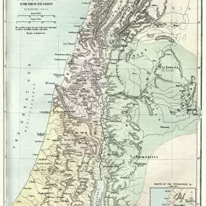
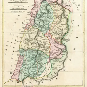
Canvas Print : Map of Palestine and the Holy Land


![]()
Canvas Prints From Mary Evans Picture Library
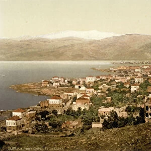
Map of Palestine and the Holy Land
Map of Palestine and the Holy Land - all places named in their Latin form. Date: 1806
Mary Evans Picture Library makes available wonderful images created for people to enjoy over the centuries
Media ID 11575327
© Mary Evans / Grenville Collins Postcard Collection
1806 Chart Damascus Dead Galilee Israel Jerusalem Maps Palestine Palestinian Ports Scale Sidon Syria Syrian Territory Tyre
20"x16" (51x41cm) Canvas Print
Introducing the captivating "Map of Palestine and the Holy Land" from our Media Storehouse Canvas Prints collection, exclusively sourced from Mary Evans Prints Online. This exquisite piece, dated 1806, showcases a detailed and intricate map of the region, with all places named in their Latin forms. With its rich history and spiritual significance, this canvas print makes a striking addition to any home or office, evoking a sense of adventure, culture, and spiritual connection. Bring the depth of history into your living space and relive the stories of the past with our high-quality canvas prints.
Delivered stretched and ready to hang our premium quality canvas prints are made from a polyester/cotton blend canvas and stretched over a 1.25" (32mm) kiln dried knot free wood stretcher bar. Packaged in a plastic bag and secured to a cardboard insert for safe transit.
Canvas Prints add colour, depth and texture to any space. Professionally Stretched Canvas over a hidden Wooden Box Frame and Ready to Hang
Estimated Product Size is 40.6cm x 50.8cm (16" x 20")
These are individually made so all sizes are approximate
Artwork printed orientated as per the preview above, with portrait (vertical) orientation to match the source image.
FEATURES IN THESE COLLECTIONS
> Arts
> Artists
> S
> Syrian Syrian
> Asia
> Israel
> Related Images
> Asia
> Palestine
> Jerusalem
> Asia
> Palestine
> Related Images
> Asia
> Syria
> Related Images
EDITORS COMMENTS
This intricately detailed map, titled "Palestina et Terra Sancta" and dated 1806, offers a glimpse into the historical geography of the Middle East, focusing on the region now known as Palestine and the Holy Land. The map, which is adorned with Latin names for various places, was created during a time when European powers were increasing their influence in the region. The map provides a clear representation of the coastal cities, including Tyre, Sidon, and Jaffa, with their ports marked as important points of entry and exit. The Dead Sea, the lowest point on Earth, is also depicted, along with the Syrian border and the bustling city of Damascus. The heart of the map, however, is the region of Galilee and Judea, which includes the ancient city of Jerusalem. The map's key reveals that the scale is set at 1:1,250,000, providing a sense of the vastness of the land. The map serves as an essential historical document, illustrating the complex geography of the region during a time of significant political and cultural change. It offers a window into the past, providing valuable context for understanding the rich history of the Middle East, particularly the Holy Land, and its enduring significance in world history.
MADE IN THE USA
Safe Shipping with 30 Day Money Back Guarantee
FREE PERSONALISATION*
We are proud to offer a range of customisation features including Personalised Captions, Color Filters and Picture Zoom Tools
SECURE PAYMENTS
We happily accept a wide range of payment options so you can pay for the things you need in the way that is most convenient for you
* Options may vary by product and licensing agreement. Zoomed Pictures can be adjusted in the Basket.