Canvas Print > Europe > France > Canton > Gard
Canvas Print : Map of Gard, France


![]()
Canvas Prints from Mary Evans Picture Library
Map of Gard, France
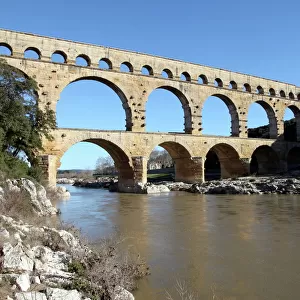
GARD A Map surrounded by the Pont du Gard, a portrait of poet and writer Jean-Pierre Claris De Florian (1755-1794) and the coat of arms
Mary Evans Picture Library makes available wonderful images created for people to enjoy over the centuries
Media ID 597269
© Mary Evans Picture Library 2015 - https://copyrighthub.org/s0/hub1/creation/maryevans/MaryEvansPictureID/10145233
1755 1794 Claris Florian Gard Maps Nimes Pierre Pont Surrounded Aqua Duct
20"x16" (51x41cm) Canvas Print
Introducing the stunning "Map of Gard, France" Canvas Print from Media Storehouse, featuring an exquisite image from Mary Evans Picture Library. This captivating print showcases a beautifully detailed map of the Gard region in France, encircled by the iconic Pont du Gard, a UNESCO World Heritage Site. Adorning the map are the portrait of Jean-Pierre Claris De Florian, a renowned poet and writer from this historic region, and the proud coat of arms of Gard. Bring the rich history and culture of France into your home with this exquisite and intricately designed canvas print. Experience the beauty of the past in vibrant, modern detail.
Delivered stretched and ready to hang our premium quality canvas prints are made from a polyester/cotton blend canvas and stretched over a 1.25" (32mm) kiln dried knot free wood stretcher bar. Packaged in a plastic bag and secured to a cardboard insert for safe transit.
Canvas Prints add colour, depth and texture to any space. Professionally Stretched Canvas over a hidden Wooden Box Frame and Ready to Hang
Estimated Product Size is 50.8cm x 40.6cm (20" x 16")
These are individually made so all sizes are approximate
Artwork printed orientated as per the preview above, with landscape (horizontal) orientation to match the source image.
FEATURES IN THESE COLLECTIONS
> Architecture
> Bridges
> Pont du Gard, France
> Arts
> Artists
> R
> Roman Roman
> Arts
> Street art graffiti
> Portraits
> Fine art
> Europe
> France
> Canton
> Gard
> Europe
> Related Images
> Maps and Charts
> Early Maps
EDITORS COMMENTS
This stunning print captures the rich history and beauty of Gard, France in exquisite detail. The map itself is a fascinating glimpse into the past, showcasing the intricate layout of this historical region. Surrounding the map is the iconic Pont du Gard, a Roman aqueduct that has stood for centuries as a testament to ancient engineering prowess.
In the center of it all is a portrait of Jean-Pierre Claris De Florian, a renowned poet and writer from the 19th century. His presence adds an air of sophistication and culture to this already captivating image. The coat of arms displayed prominently further emphasizes the importance and heritage of this region.
As you study this print, you can't help but be transported back in time to when Gard was bustling with life and activity. The combination of historical elements such as maps, writers, poets, and architectural marvels creates a truly immersive experience for anyone who gazes upon it.
Mary Evans Picture Library has expertly captured all these elements in one breathtaking composition that serves as both a work of art and a valuable historical document. It's no wonder why Gard, France continues to captivate visitors from around the world with its timeless charm and allure.
MADE IN THE USA
Safe Shipping with 30 Day Money Back Guarantee
FREE PERSONALISATION*
We are proud to offer a range of customisation features including Personalised Captions, Color Filters and Picture Zoom Tools
SECURE PAYMENTS
We happily accept a wide range of payment options so you can pay for the things you need in the way that is most convenient for you
* Options may vary by product and licensing agreement. Zoomed Pictures can be adjusted in the Cart.