
Canvas Print : Map / Central Africa C1860


![]()
Canvas Prints from Mary Evans Picture Library
Map / Central Africa C1860
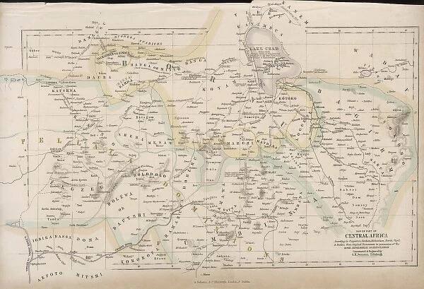
Map of Central Africa
Mary Evans Picture Library makes available wonderful images created for people to enjoy over the centuries
Media ID 4357799
© Mary Evans Picture Library 2015 - https://copyrighthub.org/s0/hub1/creation/maryevans/MaryEvansPictureID/10113838
30"x20" (76x51cm) Canvas Print
"Discover the captivating history of Central Africa with our exquisite Canvas Prints from Media Storehouse. Featuring the intricately detailed Map of Central Africa from 1860, sourced from Mary Evans Prints Online, these high-quality prints are a stunning addition to any home or office. Each print is meticulously reproduced on canvas for an impressive textured finish, bringing the rich history of Central Africa to life. Our Canvas Prints are not only beautiful works of art but also valuable historical records, making them a unique and thoughtful gift for history enthusiasts and world travelers alike. Order yours today and let the story of Central Africa unfold in your space."
Delivered stretched and ready to hang our premium quality canvas prints are made from a polyester/cotton blend canvas and stretched over a 1.25" (32mm) kiln dried knot free wood stretcher bar. Packaged in a plastic bag and secured to a cardboard insert for safe transit.
Canvas Prints add colour, depth and texture to any space. Professionally Stretched Canvas over a hidden Wooden Box Frame and Ready to Hang
Estimated Product Size is 76.2cm x 50.8cm (30" x 20")
These are individually made so all sizes are approximate
Artwork printed orientated as per the preview above, with landscape (horizontal) orientation to match the source image.
EDITORS COMMENTS
This print showcases a detailed map of Central Africa from around 1860. The intricate details and historical significance of this map make it a fascinating piece to study and admire. From the various regions and cities depicted, to the rivers, mountains, and borders outlined, every aspect of this map offers insight into the geography and political landscape of Central Africa during that time period.
The vintage aesthetic of this map adds to its charm, transporting viewers back in time to an era when exploration and discovery were at the forefront. It serves as a reminder of the rich history and cultural heritage that has shaped Central Africa over centuries.
Whether you have a passion for cartography or simply appreciate historical artifacts, this print is sure to captivate your imagination. Displaying it in your home or office will not only add a touch of sophistication but also spark conversations about the evolution of maps and their role in shaping our understanding of different regions.
Overall, this Map / Central Africa C1860 print is more than just a decorative piece – it's a window into the past that invites us to explore and learn about one of the most diverse continents on Earth.
MADE IN THE USA
Safe Shipping with 30 Day Money Back Guarantee
FREE PERSONALISATION*
We are proud to offer a range of customisation features including Personalised Captions, Color Filters and Picture Zoom Tools
SECURE PAYMENTS
We happily accept a wide range of payment options so you can pay for the things you need in the way that is most convenient for you
* Options may vary by product and licensing agreement. Zoomed Pictures can be adjusted in the Cart.