Canvas Print : Map / Africa 1884 Graphic
![]()

Canvas Prints from Mary Evans Picture Library
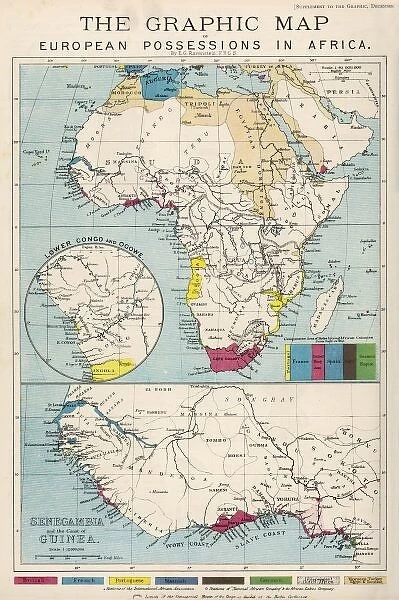
Map / Africa 1884 Graphic
Map of Africa showing European Possessions
Mary Evans Picture Library makes available wonderful images created for people to enjoy over the centuries
Media ID 608764
© Mary Evans Picture Library 2015 - https://copyrighthub.org/s0/hub1/creation/maryevans/MaryEvansPictureID/10113831
30"x20" (76x51cm) Canvas Print
Discover the captivating allure of our Media Storehouse Canvas Prints, featuring the iconic "Map / Africa 1884 Graphic" by Mary Evans Picture Library from Mary Evans Prints Online. This exquisite piece of historical cartography transports you back in time, showcasing European possessions in Africa during the late 19th century. Each canvas print is meticulously crafted with premium materials, ensuring vibrant colors and stunning detail that bring this intriguing map to life. Elevate your home or office décor with a piece of art that tells a story, while adding an air of sophistication and intrigue. Experience the beauty of history in your own space with our high-quality Canvas Prints.
Delivered stretched and ready to hang our premium quality canvas prints are made from a polyester/cotton blend canvas and stretched over a 1.25" (32mm) kiln dried knot free wood stretcher bar. Packaged in a plastic bag and secured to a cardboard insert for safe transit.
Canvas Prints add colour, depth and texture to any space. Professionally Stretched Canvas over a hidden Wooden Box Frame and Ready to Hang
Estimated Product Size is 50.8cm x 76.2cm (20" x 30")
These are individually made so all sizes are approximate
Artwork printed orientated as per the preview above, with portrait (vertical) orientation to match the source image.
EDITORS COMMENTS
This print from Mary Evans Picture Library showcases a historical map of Africa dating back to 1884. The intricate graphic details on the map provide a fascinating insight into the European possessions in Africa during that period. Each line, color, and label on the map tells a story of colonization, exploration, and power struggles that shaped the continent's history.
The map is not just a geographical representation but also serves as a visual narrative of imperialism and conquest in Africa. It highlights how various European countries divided up the land for their own economic interests, often disregarding the existing borders and cultures of indigenous peoples.
As we study this detailed depiction of African territories under European control in 1884, we are reminded of the complex legacy left by colonialism on the continent. This print serves as a valuable educational tool for understanding historical events that continue to impact Africa today.
Whether you are a history enthusiast, cartography buff, or simply appreciate fine art prints, this Map / Africa 1884 Graphic offers an engaging glimpse into a pivotal moment in African history. Explore this remarkable piece from Mary Evans Prints Online and immerse yourself in the rich tapestry of Africa's past.
MADE IN THE USA
Safe Shipping with 30 Day Money Back Guarantee
FREE PERSONALISATION*
We are proud to offer a range of customisation features including Personalised Captions, Color Filters and Picture Zoom Tools
SECURE PAYMENTS
We happily accept a wide range of payment options so you can pay for the things you need in the way that is most convenient for you
* Options may vary by product and licensing agreement. Zoomed Pictures can be adjusted in the Cart.


