Canvas Print : Europe Trade W. Asia Map


![]()
Canvas Prints from Mary Evans Picture Library
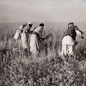
Europe Trade W. Asia Map
A map showing the extent of European trade with Asia in the 18th century
Mary Evans Picture Library makes available wonderful images created for people to enjoy over the centuries
Media ID 600409
© Mary Evans Picture Library 2015 - https://copyrighthub.org/s0/hub1/creation/maryevans/MaryEvansPictureID/10138034
1730 Extent Persia Routes Tartary
20"x16" (51x41cm) Canvas Print
Discover the rich history of European trade with Asia in the 18th century with our stunning Canvas Prints from Media Storehouse, featuring the captivating "Europe Trade W. Asia Map" by Mary Evans Picture Library from Mary Evans Prints Online. This beautifully detailed map offers a fascinating insight into the extensive maritime routes and commercial connections that bound Europe and Asia during this period. Each print is expertly crafted on high-quality canvas, ensuring vibrant colors and sharp details that bring the history to life. Add this exquisite piece to your home or office to ignite conversation and inspire curiosity about the past.
Delivered stretched and ready to hang our premium quality canvas prints are made from a polyester/cotton blend canvas and stretched over a 1.25" (32mm) kiln dried knot free wood stretcher bar. Packaged in a plastic bag and secured to a cardboard insert for safe transit.
Canvas Prints add colour, depth and texture to any space. Professionally Stretched Canvas over a hidden Wooden Box Frame and Ready to Hang
Estimated Product Size is 50.8cm x 40.6cm (20" x 16")
These are individually made so all sizes are approximate
Artwork printed orientated as per the preview above, with landscape (horizontal) orientation to match the source image.
EDITORS COMMENTS
This fascinating print from Mary Evans Picture Library showcases a detailed map illustrating the extensive trade routes between Europe and Asia during the 18th century. The map, dating back to around 1730, provides a historical glimpse into the flourishing commerce that took place between these two continents centuries ago.
The intricate details on the map highlight key trading hubs such as China, India, Persia, and Tartary (Central Asia), showcasing how goods and commodities were exchanged along these established routes. It is evident from this visual representation that trade played a significant role in shaping diplomatic relations and cultural exchanges between European nations and their Asian counterparts during this period.
As we study this map closely, we can appreciate the vast extent of economic interactions that occurred across vast distances, bridging different civilizations and fostering mutual prosperity. The lines connecting various regions symbolize not just physical trade routes but also connections of ideas, technologies, and traditions that enriched both European and Asian societies.
Overall, this print serves as a valuable historical document shedding light on the complex network of trade relationships that existed between Europe and West Asia in the 18th century. It invites us to reflect on how these exchanges have influenced our modern global economy and interconnected world today.
MADE IN THE USA
Safe Shipping with 30 Day Money Back Guarantee
FREE PERSONALISATION*
We are proud to offer a range of customisation features including Personalised Captions, Color Filters and Picture Zoom Tools
SECURE PAYMENTS
We happily accept a wide range of payment options so you can pay for the things you need in the way that is most convenient for you
* Options may vary by product and licensing agreement. Zoomed Pictures can be adjusted in the Cart.