Canvas Print > Arts > Artists > S > John Speed
Canvas Print : Old Map of The Province of Munster, Ireland 1611 by John Speed


Canvas Prints From MapSeeker
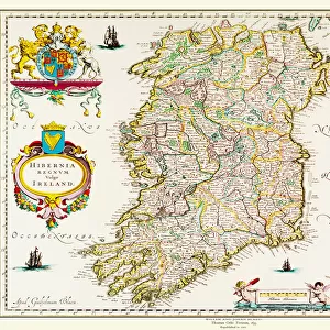
Old Map of The Province of Munster, Ireland 1611 by John Speed
A facimile of John Speeds historical map of the Province of Munster originally published for the " Theatre of the Empire of Great Britain", an atlas to accompany " a history of Great Britain"
Welcome to the Mapseeker Image library and enter an historic gateway to one of the largest on-line collections of Historic Maps, Nostalgic Views, Vista's and Panorama's from a World gone by.
Media ID 20347739
© Mapseeker Publishing Ltd
Historic Map John Speed Map Speed Map Speede Map Munster
30"x20" (76x51cm) Canvas Print
Step back in time with our exquisite Canvas Prints from Media Storehouse, featuring an Old Map of the Province of Munster, Ireland, 1611. Meticulously reproduced from the original map by renowned cartographer John Speed, this captivating piece showcases intricate detail and historical accuracy. Perfectly recreating the antiquated charm, these Canvas Prints are not just decorative pieces, but a window into the past. Bring history into your home and add a touch of timeless beauty with our Old Map of Munster Canvas Prints.
Delivered stretched and ready to hang our premium quality canvas prints are made from a polyester/cotton blend canvas and stretched over a 1.25" (32mm) kiln dried knot free wood stretcher bar. Packaged in a plastic bag and secured to a cardboard insert for safe transit.
Canvas Prints add colour, depth and texture to any space. Professionally Stretched Canvas over a hidden Wooden Box Frame and Ready to Hang
Estimated Product Size is 76.2cm x 50.8cm (30" x 20")
These are individually made so all sizes are approximate
Artwork printed orientated as per the preview above, with landscape (horizontal) orientation to match the source image.
FEATURES IN THESE COLLECTIONS
> Arts
> Artists
> S
> John Speed
> Europe
> Republic of Ireland
> Maps
> Maps and Charts
> British Empire Maps
> Maps and Charts
> Early Maps
EDITORS COMMENTS
This print showcases an exquisite reproduction of the "Old Map of The Province of Munster, Ireland 1611" by John Speed. Originally published as part of the renowned "Theatre of the Empire of Great Britain" this map served as an essential component in illustrating the rich history and heritage of Great Britain. With intricate details and meticulous craftsmanship, John Speed's historical map offers a fascinating glimpse into the province of Munster during the early 17th century. From its vibrant cities to its sprawling landscapes, every corner is meticulously depicted, providing a visual journey through time. As one explores this facsimile edition, they will discover a wealth of information about Ireland's provinces and their interconnections. This particular map focuses on Munster—a region steeped in ancient folklore and storied traditions. Its rivers, mountains, towns, and castles are all carefully labeled with elegant calligraphy that adds to its allure. Whether you are an avid historian or simply captivated by cartography's beauty, this old map is sure to transport you back in time. It serves as a testament to John Speed's remarkable skill in capturing not only geographical accuracy but also cultural significance. Displaying this historic piece within your home or office will undoubtedly spark conversations about Ireland's past while adding a touch of timeless elegance to any space.
MADE IN THE USA
Safe Shipping with 30 Day Money Back Guarantee
FREE PERSONALISATION*
We are proud to offer a range of customisation features including Personalised Captions, Color Filters and Picture Zoom Tools
SECURE PAYMENTS
We happily accept a wide range of payment options so you can pay for the things you need in the way that is most convenient for you
* Options may vary by product and licensing agreement. Zoomed Pictures can be adjusted in the Basket.