Canvas Print > Arts > Artists > S > John Speed
Canvas Print : Old County Map of Lincolnshire 1611 by John Speed


Canvas Prints From MapSeeker
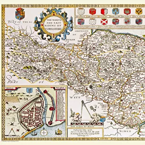
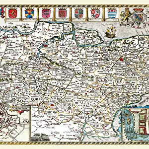
Old County Map of Lincolnshire 1611 by John Speed
A facimile of John Speeds historical map of Lincolnshire originally published for the " Theatre of the Empire of Great Britain", an atlas to accompany " a history of Great Britain"
Welcome to the Mapseeker Image library and enter an historic gateway to one of the largest on-line collections of Historic Maps, Nostalgic Views, Vista's and Panorama's from a World gone by.
Media ID 20347554
© Mapseeker Publishing Ltd
County Map County Map Of England English County Map Historic Map John Speed Map Old County Map Old English County Map Speed Map Speede Map Lincolnshire
30"x20" (76x51cm) Canvas Print
Step back in time with our Old County Map of Lincolnshire 1611 by John Speed from the Media Storehouse Canvas Prints collection. This stunning facsimile of the historical map, originally published as part of the "Theatre of the Empire of Great Britain," transports you to an era of exploration and discovery. John Speed's intricate cartography captures the intricacies of Lincolnshire's topography during the early 17th century. Each canvas print is meticulously crafted with vibrant colors and sharp details, making it a captivating addition to your home or office space. Experience the rich history of Lincolnshire like never before with this beautiful and authentic reproduction.
Delivered stretched and ready to hang our premium quality canvas prints are made from a polyester/cotton blend canvas and stretched over a 1.25" (32mm) kiln dried knot free wood stretcher bar. Packaged in a plastic bag and secured to a cardboard insert for safe transit.
Canvas Prints add colour, depth and texture to any space. Professionally Stretched Canvas over a hidden Wooden Box Frame and Ready to Hang
Estimated Product Size is 76.2cm x 50.8cm (30" x 20")
These are individually made so all sizes are approximate
Artwork printed orientated as per the preview above, with landscape (horizontal) orientation to match the source image.
FEATURES IN THESE COLLECTIONS
> Arts
> Artists
> S
> John Speed
> Europe
> United Kingdom
> England
> Lincolnshire
> Related Images
> Europe
> United Kingdom
> England
> Maps
> Maps and Charts
> British Empire Maps
> Maps and Charts
> Early Maps
> MapSeeker
> Maps from the British Isles
> England and Counties PORTFOLIO
EDITORS COMMENTS
This print showcases the "Old County Map of Lincolnshire 1611" by John Speed, a renowned cartographer of his time. Originally published for the esteemed "Theatre of the Empire of Great Britain" an atlas that accompanied a comprehensive history of Great Britain, this facsimile offers a glimpse into the rich historical tapestry of Lincolnshire. With its intricate details and exquisite craftsmanship, this old English county map transports us back to a bygone era. Every stroke on this map tells a story, revealing the evolution and boundaries of Lincolnshire in 1611. As we explore its contours and landmarks, we can't help but marvel at how much has changed over centuries. John Speed's expertise shines through in every corner as he meticulously captures not only geographical features but also important towns, villages, rivers, and roads that were integral to life in Lincolnshire during that period. This historic map serves as both an educational tool and a window into our past. Whether you are an avid historian or simply appreciate fine artistry, this print is sure to captivate your imagination. It allows you to connect with the roots of England's counties while admiring John Speed's remarkable contribution to cartography. Let this piece transport you back in time as you delve into the fascinating world depicted on this treasured historical lincolnshire map from 1611
MADE IN THE USA
Safe Shipping with 30 Day Money Back Guarantee
FREE PERSONALISATION*
We are proud to offer a range of customisation features including Personalised Captions, Color Filters and Picture Zoom Tools
SECURE PAYMENTS
We happily accept a wide range of payment options so you can pay for the things you need in the way that is most convenient for you
* Options may vary by product and licensing agreement. Zoomed Pictures can be adjusted in the Basket.