Canvas Print > Maps and Charts > Related Images
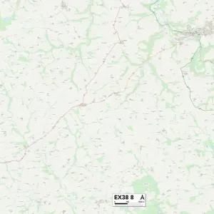
Canvas Print : Exeter EX9 7 Map


![]()
Canvas Prints From Map Marketing
Exeter EX9 7 Map
Postcode Sector Map of Exeter EX9 7
Media ID 19970127
All Saints Close Bay Road Bell Street Brookfield Road Chichester Way Church Hill Cliff Lane Cranes Lane Dukes Close Exeter Fore Street Frogmore Road Glebe Close Hayes Close Hayes Lane High Street Knowle Hill Lea Lane Lea Road Middle Street Oak Hill Orchard Close Orchard Drive Park Lane Priory Close Ropers Lane Russell Drive Rydon Lane St Michaels Close Vicarage Road
20"x16" (51x41cm) Canvas Print
Delivered stretched and ready to hang our premium quality canvas prints are made from a polyester/cotton blend canvas and stretched over a 1.25" (32mm) kiln dried knot free wood stretcher bar. Packaged in a plastic bag and secured to a cardboard insert for safe transit.
Canvas Prints add colour, depth and texture to any space. Professionally Stretched Canvas over a hidden Wooden Box Frame and Ready to Hang
Estimated Product Size is 50.8cm x 40.6cm (20" x 16")
These are individually made so all sizes are approximate
Artwork printed orientated as per the preview above, with landscape (horizontal) orientation to match the source image.
FEATURES IN THESE COLLECTIONS
> Maps and Charts
> Related Images
> Map Marketing
> Postcode Sector Maps
> EX - Exeter
> Map Marketing
> UK Maps
MADE IN THE USA
Safe Shipping with 30 Day Money Back Guarantee
FREE PERSONALISATION*
We are proud to offer a range of customisation features including Personalised Captions, Color Filters and Picture Zoom Tools
SECURE PAYMENTS
We happily accept a wide range of payment options so you can pay for the things you need in the way that is most convenient for you
* Options may vary by product and licensing agreement. Zoomed Pictures can be adjusted in the Basket.