Canvas Print > North America > United States of America > Texas > Houston
Canvas Print : Houston City Map


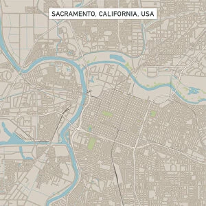
![]()
Canvas Prints From Map Marketing
Houston City Map
A street level map of central Houston based on USGS topo map data. Covers from the North Loop Freeway in the north to Riverside Terrace in the south and from Magnolia Park in the east to the Memorial Park in the west
Media ID 19949312
© Map Marketing Ltd, Map Data courtesy of USGS
20"x16" (51x41cm) Canvas Print
Delivered stretched and ready to hang our premium quality canvas prints are made from a polyester/cotton blend canvas and stretched over a 1.25" (32mm) kiln dried knot free wood stretcher bar. Packaged in a plastic bag and secured to a cardboard insert for safe transit.
Canvas Prints add colour, depth and texture to any space. Professionally Stretched Canvas over a hidden Wooden Box Frame and Ready to Hang
Estimated Product Size is 50.8cm x 40.6cm (20" x 16")
These are individually made so all sizes are approximate
Artwork printed orientated as per the preview above, with landscape (horizontal) orientation to match the source image.
FEATURES IN THESE COLLECTIONS
> Maps and Charts
> Related Images
> North America
> United States of America
> Texas
> Houston
MADE IN THE USA
Safe Shipping with 30 Day Money Back Guarantee
FREE PERSONALISATION*
We are proud to offer a range of customisation features including Personalised Captions, Color Filters and Picture Zoom Tools
SECURE PAYMENTS
We happily accept a wide range of payment options so you can pay for the things you need in the way that is most convenient for you
* Options may vary by product and licensing agreement. Zoomed Pictures can be adjusted in the Basket.