Canvas Print > Animals > Mammals > Archaeolemuridae > Majori
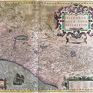
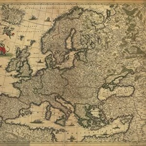
Canvas Print : Map Tabula TartariAŠ et majoris partis regni ChinAŠ


![]()
Canvas Prints from Liszt Collection
Map Tabula TartariAŠ et majoris partis regni ChinAŠ
Map, Tabula Tartariae et majoris partis regni Chinae, edita a F. de Wit Lhuilier fecit, Frederick de Wit (1630-1706), Joannes Lhuilier, Copperplate print
Liszt Collection of nineteenth-century engravings and images to browse and enjoy
Media ID 19584928
© Artokoloro
1630 1706 Copperplate Print Frederick De Wit
20"x16" (51x41cm) Canvas Print
Discover the captivating allure of the past with our Media Storehouse Canvas Prints. This exquisite piece features the Tabula Tartariae et majoris partis regni Chinae map, hailing from the renowned Liszt Collection. Meticulously crafted from a copperplate print by Frederick de Wit and Joannes Lhuilier, this vintage map of China and its neighboring regions transports you back in time. Rich in historical detail and intrigue, our premium canvas prints bring the beauty of antique cartography into your modern home.
Delivered stretched and ready to hang our premium quality canvas prints are made from a polyester/cotton blend canvas and stretched over a 1.25" (32mm) kiln dried knot free wood stretcher bar. Packaged in a plastic bag and secured to a cardboard insert for safe transit.
Canvas Prints add colour, depth and texture to any space. Professionally Stretched Canvas over a hidden Wooden Box Frame and Ready to Hang
Estimated Product Size is 50.8cm x 40.6cm (20" x 16")
These are individually made so all sizes are approximate
Artwork printed orientated as per the preview above, with landscape (horizontal) orientation to match the source image.
FEATURES IN THESE COLLECTIONS
> Animals
> Mammals
> Archaeolemuridae
> Majori
> Arts
> Artists
> W
> Frederick de Wit
> Maps and Charts
> Related Images
EDITORS COMMENTS
This print showcases a historical treasure, the "Map Tabula Tartariæ et majoris partis regni Chinæ" meticulously crafted by Frederick de Wit and Joannes Lhuilier. Created in the 17th century, this copperplate print offers a fascinating glimpse into the cartographic knowledge of that era. The map itself is an exquisite work of art, displaying intricate details and ornate illustrations. It depicts Tartary and a significant portion of China's kingdom, providing valuable insights into their geographical boundaries during that time. The craftsmanship involved in producing this piece is truly remarkable. Frederick de Wit (1630-1706), renowned for his expertise in cartography, collaborated with Joannes Lhuilier to bring this masterpiece to life. Their combined efforts resulted in an accurate representation of these regions, showcasing their dedication to precision and accuracy. As we admire this print from the Liszt Collection, we are transported back in time to an era where maps were not only functional but also works of art. This particular piece serves as a testament to human curiosity and exploration. Whether you are an avid history enthusiast or simply appreciate fine craftsmanship, this print allows you to immerse yourself in the rich tapestry of our past. It serves as a reminder that even centuries ago, people strived to understand the world around them through meticulous mapping techniques like those employed by De Wit and Lhuilier.
MADE IN THE USA
Safe Shipping with 30 Day Money Back Guarantee
FREE PERSONALISATION*
We are proud to offer a range of customisation features including Personalised Captions, Color Filters and Picture Zoom Tools
SECURE PAYMENTS
We happily accept a wide range of payment options so you can pay for the things you need in the way that is most convenient for you
* Options may vary by product and licensing agreement. Zoomed Pictures can be adjusted in the Cart.