Canvas Print > Asia > Japan > Maps
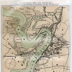
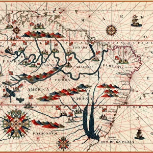
Canvas Print : China and Japan, c1903, (1904)
")
")

![]()
Canvas Prints From Heritage Images
China and Japan, c1903, (1904)
China and Japan, c1903, (1904). From The Worlds History, Volume II, by Dr. H. F. Helmolt [William Heinemann, London, 1904]
Heritage Images features heritage image collections
Media ID 14969802
© The Print Collector
Cartography Dr H F Helmolt Dr Hf Helmolt H F Helmolt Hans F Hans F Hans Ferdinand Hans Ferdinand Hans Ferdinand Helmolt Helmolt Hf Helmolt Map Making The Worlds History William Heinemann William Heinemann Ltd Wmheinemann World
20"x16" (51x41cm) Canvas Print
Experience the rich history of China and Japan in the early 20th century with this stunning canvas print from Media Storehouse. This captivating image, taken from "The Worlds History, Volume II" by Dr. H.F. Helmolt (William Heinemann, London, 1904), beautifully portrays the unique cultural connections between these two ancient civilizations during an influential era. Bring the history of China and Japan into your home or office with this high-quality canvas print, expertly printed on heavy-duty canvas and coated with a protective, scratch-resistant finish. Each print is hand-stretched over solid wood stretcher bars, ensuring a professional gallery-quality appearance that will last for years to come. Transport yourself back in time and add a touch of history to your space with this exquisite canvas print from Media Storehouse.
Delivered stretched and ready to hang our premium quality canvas prints are made from a polyester/cotton blend canvas and stretched over a 1.25" (32mm) kiln dried knot free wood stretcher bar. Packaged in a plastic bag and secured to a cardboard insert for safe transit.
Canvas Prints add colour, depth and texture to any space. Professionally Stretched Canvas over a hidden Wooden Box Frame and Ready to Hang
Estimated Product Size is 50.8cm x 40.6cm (20" x 16")
These are individually made so all sizes are approximate
Artwork printed orientated as per the preview above, with landscape (horizontal) orientation to match the source image.
FEATURES IN THESE COLLECTIONS
> Arts
> Literature
> Illustration
> Asia
> Japan
> Related Images
> Asia
> Related Images
> Europe
> United Kingdom
> England
> London
> Related Images
> Maps and Charts
> Related Images
> Maps and Charts
> World
EDITORS COMMENTS
This print from 1904 showcases the historical connection between China and Japan. The image, taken from Dr. H. F. Helmolt's book "The World's History" transports us back to a time when these two Asian nations were on the brink of significant change and transformation. In this beautifully illustrated map, we see the intricate details of both countries' geography and boundaries. The delicate pink hues add an artistic touch to the otherwise informative depiction of Asia's continent. It is a testament to the skillful cartography prevalent during that era. As we gaze upon this snapshot frozen in time, it evokes a sense of curiosity about what life was like in early 20th-century China and Japan. This print serves as a visual reminder of their shared history, cultural exchange, and geographical proximity. Furthermore, it highlights how literature played an essential role in disseminating knowledge about different parts of the world at that time. Driven by exploration and curiosity, scholars like Dr. H. F. Helmolt dedicated themselves to creating comprehensive works that would educate generations to come. Today, this print stands as a valuable artifact representing not only historical documentation but also artistry through its vibrant colors and meticulous attention to detail. It invites us to reflect on our interconnectedness as nations while appreciating the beauty found within maps – windows into our pasts waiting patiently for discovery once again.
MADE IN THE USA
Safe Shipping with 30 Day Money Back Guarantee
FREE PERSONALISATION*
We are proud to offer a range of customisation features including Personalised Captions, Color Filters and Picture Zoom Tools
SECURE PAYMENTS
We happily accept a wide range of payment options so you can pay for the things you need in the way that is most convenient for you
* Options may vary by product and licensing agreement. Zoomed Pictures can be adjusted in the Basket.