Canvas Print > Arts > Landscape paintings > Waterfall and river artworks > River artworks
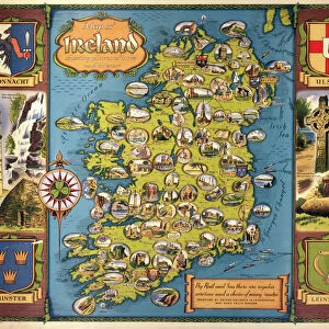
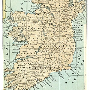
Canvas Print : MAP: IRELAND, 1851. An engraved map of Ireland, 1851


![]()
Canvas Prints From Granger
MAP: IRELAND, 1851. An engraved map of Ireland, 1851
Granger holds millions of images spanning more than 25,000 years of world history, from before the Stone Age to the dawn of the Space Age
Media ID 7514075
30"x20" (76x51cm) Canvas Print
Discover the rich history of Ireland with our stunning Canvas Print of "MAP: IRELAND, 1851" from The Granger Collection. This exquisite engraved map, dating back to 1851, offers a captivating glimpse into the past. The intricate details and vibrant colors are brought to life on high-quality canvas, creating a beautiful piece of art that tells a story. Perfect for history enthusiasts, travellers or those with Irish heritage, this unique Canvas Print adds character and depth to any room. Bring the past into your present with Media Storehouse's premium Canvas Prints.
Delivered stretched and ready to hang our premium quality canvas prints are made from a polyester/cotton blend canvas and stretched over a 1.25" (32mm) kiln dried knot free wood stretcher bar. Packaged in a plastic bag and secured to a cardboard insert for safe transit.
Canvas Prints add colour, depth and texture to any space. Professionally Stretched Canvas over a hidden Wooden Box Frame and Ready to Hang
Estimated Product Size is 50.8cm x 76.2cm (20" x 30")
These are individually made so all sizes are approximate
Artwork printed orientated as per the preview above, with portrait (vertical) orientation to match the source image.
FEATURES IN THESE COLLECTIONS
> Arts
> Landscape paintings
> Waterfall and river artworks
> River artworks
> Europe
> Republic of Ireland
> Maps
> Maps and Charts
> Related Images
EDITORS COMMENTS
This print showcases an exquisite engraved map of Ireland from the year 1851. The intricate details and craftsmanship of this historical artifact transport us back to a time when cartography was both an art form and a vital tool for exploration. Every line, curve, and contour on this map tells a story of Ireland's rich history and geography. The middle section of the map captures the essence of Ireland with its lush green landscapes, rolling hills, and meandering rivers. It offers a glimpse into the country's diverse topography that has shaped its culture over centuries. As our eyes wander across the engraving, we can almost feel ourselves traversing through Irish towns and villages nestled along these winding waterways. Beyond its aesthetic appeal, this engraved map holds immense historical significance. It serves as a window into 19th-century Ireland – a period marked by political unrest, famine, and cultural revival. This piece is not just about geographical boundaries; it encapsulates the spirit of resilience embodied by the Irish people during challenging times. Thanks to Granger Art on Demand's meticulous preservation efforts, we are fortunate to have access to such remarkable artifacts like this one. Whether you are an avid historian or simply appreciate fine artistry, this print is sure to captivate your imagination while offering insights into Ireland's past like never before.
MADE IN THE USA
Safe Shipping with 30 Day Money Back Guarantee
FREE PERSONALISATION*
We are proud to offer a range of customisation features including Personalised Captions, Color Filters and Picture Zoom Tools
SECURE PAYMENTS
We happily accept a wide range of payment options so you can pay for the things you need in the way that is most convenient for you
* Options may vary by product and licensing agreement. Zoomed Pictures can be adjusted in the Basket.