Canvas Print > Arts > Artists > O > Abraham Ortelius
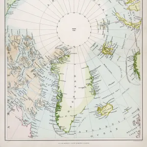
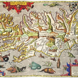
Canvas Print : ICELAND: MAP, 1595. Map of Iceland from a 1595 edition of Abraham Ortelius atlas Theatrum


![]()
Canvas Prints From Granger
ICELAND: MAP, 1595. Map of Iceland from a 1595 edition of Abraham Ortelius atlas Theatrum
ICELAND: MAP, 1595. Map of Iceland from a 1595 edition of Abraham Ortelius atlas Theatrum Orbis Terrarum
Granger holds millions of images spanning more than 25,000 years of world history, from before the Stone Age to the dawn of the Space Age
Media ID 6617533
1595 Abraham Atlas Iceland Ortelius Theatrum Orbis Terrarum
30"x20" (76x51cm) Canvas Print
Discover the captivating history of Iceland with our exquisite Canvas Prints from Media Storehouse. Featuring an intriguing map of Iceland from a 1595 edition of Abraham Ortelius' renowned atlas, Theatrum Orbis Terrarum, these prints bring the past to life. The Granger Collection's Iceland map, showcasing intricate details and rich history, is a must-have for history enthusiasts, world travelers, and those who appreciate the beauty of antique cartography. Bring a piece of the past into your home or office with our high-quality Canvas Prints, expertly printed and carefully crafted to preserve the intricacies of this historical masterpiece.
Delivered stretched and ready to hang our premium quality canvas prints are made from a polyester/cotton blend canvas and stretched over a 1.25" (32mm) kiln dried knot free wood stretcher bar. Packaged in a plastic bag and secured to a cardboard insert for safe transit.
Canvas Prints add colour, depth and texture to any space. Professionally Stretched Canvas over a hidden Wooden Box Frame and Ready to Hang
Estimated Product Size is 76.2cm x 50.8cm (30" x 20")
These are individually made so all sizes are approximate
Artwork printed orientated as per the preview above, with landscape (horizontal) orientation to match the source image.
FEATURES IN THESE COLLECTIONS
> Arts
> Artists
> O
> Abraham Ortelius
> Arts
> Landscape paintings
> Waterfall and river artworks
> River artworks
> Europe
> Iceland
> Related Images
> Maps and Charts
> Abraham Ortelius
> Maps and Charts
> Related Images
EDITORS COMMENTS
This print showcases a rare gem from the past - a map of Iceland dating back to 1595. This historical artifact is part of Abraham Ortelius' renowned atlas, Theatrum Orbis Terrarum, which was considered one of the most influential cartographic works of its time. The intricate details and craftsmanship on this map are truly remarkable. It offers a glimpse into how Iceland was perceived during the late 16th century, providing valuable insights into the geographical knowledge and exploration efforts of that era. As we examine this ancient map, we can observe various features such as rivers meandering through the Icelandic landscape, highlighting their significance in shaping both nature and human settlements. The delicate lines and precise labeling demonstrate Ortelius' dedication to accuracy in his cartographic endeavors. This print serves as a window to history, allowing us to appreciate the artistry and scientific advancements made centuries ago. It invites us to reflect upon our own understanding of geography today while acknowledging those who paved the way for modern mapping techniques. With its rich historical context and visual allure, this image from The Granger Collection's archives is an ideal addition for any enthusiast seeking to explore Iceland's past or simply admire the beauty found within antique maps.
MADE IN THE USA
Safe Shipping with 30 Day Money Back Guarantee
FREE PERSONALISATION*
We are proud to offer a range of customisation features including Personalised Captions, Color Filters and Picture Zoom Tools
SECURE PAYMENTS
We happily accept a wide range of payment options so you can pay for the things you need in the way that is most convenient for you
* Options may vary by product and licensing agreement. Zoomed Pictures can be adjusted in the Basket.